

The Buffalo and Native Peoples on the Upper Missouri
Written by John P. Joyce.
The three streams, Cheyenne, Moreau and Grand River, approach more nearly to each other than the rest. In most of the small streams forming these rivers beavers used to be found in great abundance. Lately they have very rare…Of all the rivers Grand River is the largest,
And the Early Historians, Artists and Scientists
Who Described Them
Written by John P. Joyce
Edwin Denig: Fur Trader-Historian 1833-1856
George Catlin John James Audubon Prince Maximilian and Karl Bodmer
The Writer’s Struggles with Their Message
Edwin Denig: Fur Trader—Historian 1833-1856
The three streams, Cheyenne, Moreau and Grand River, approach more nearly to each other than the rest. In most of the small streams forming these rivers beavers used to be found in great abundance. Lately they have become very rare…Of all the rivers Grand River is the largest, best wooded and best stocked with game. Buffalo are found along this river when the rest of the country has none. Elk ‘rove’ through the large points in droves of several hundred. Antelope in large bands cover the hills. The fertile coulees are the home to blacktail deer and the woods that of red deer.
—Edwin Thompson Denig,
bourgeois (chief trader),
Fort Union,
Yellowstone-Missouri River confluence, 1856.[1]

A view of Fort Union Trading Post taken from the north at Bodmer Overlook, the spot where Swiss artist Karl Bodmer sketched his famous drawing of the most prominent fur trade post on the Upper Missouri River. Passing by the trading post's front, or south, gate, the Missouri River was the major transportation route into the northern plains during the fort's active years, 1828-1867. Photo by Emily Sunblade. National Park Service.
By the time Edwin Denig wrote the above assessment in 1856 buffalo numbers had been in decline on the Northern Plains for two decades. This resulted from several cultural and ecological forces with the more notable decline due to the market for robes, tongues and hides. From the early 1830s to the late 1840s the trade in buffalo robes increased significantly. By then the buffalo’s skin had become the most marketable natural resource on the Great Plains. As early as 1846 Denig observed that the buffalo on the Northern Plains were becoming “rapidly more scarce.”[2]
For thousands of years the fate of the plains peoples had always been tied to the fate of the buffalo. They revered the buffalo as sacred brothers and sisters and put the buffalo at the center of their spiritual world. Buffalo herds had flourished during the Little Ice Age (roughly AD 1500-1800) from the resulting cooler, wetter climate more favorable for plains grass production. As a result, according to historian-authors, Dan Flores and Andrew C. Isenberg, there was an estimated twenty-eight to thirty-million buffalo on the Great Plains at the time of the 1804-06 Lewis and Clark expedition. North Dakota conceivably could have had a total buffalo population in the one-two million range at that time. North Dakota’s climate was temperate and its short and mixed grass (blue grama, buffalo, little bluestem, needle-and-thread grass) prairie distribution covered most of the state’s western two-thirds. The buffalo had a preference for short grasses due to their high ratio of protein to carbohydrates.[3]
According to western tree ring studies, after 1820-21, dryer, warmer conditions less favorable for grass ensued culminating in the great drought period of 1856-64. Dan Flores points out the research by anthropologist Reid Bryson led him to believe that climate change and other factors adversely impacted the buffalo numbers. This included negative influences such as prairie encroachment from settlers on the east and west margins of the plains, grass competition from other grazers such as wild horses, and the possible impact of diseases such as anthrax and bovine tuberculosis. Taken all together they could have had an overall reduction of Great Plains bison carrying capacity of 40-60%. By the time of the civil war, 1861-65, Flores estimates that buffalo numbers fell to ten to twelve million.[4]
The Little Ice Age also enabled wild horse numbers from the Spanish settlements of present-day Texas and New Mexico to increase and rapidly expand northward. By the mid-eighteenth century horses were common on the Northern Plains which enabled emerging woodland cultures from the Great Lakes Region such as the Assiniboine, Cheyenne, and Dakotas consisting of three divisions, Santee, Yankton-Yanktonai, and Teton. (today’s Dakota, Nakota, Lakota) All three divisions migrated to the prairie though it was the Tetons who adapted to full time nomadic hunting of migrating buffalo herds beyond the Missouri River. By 1805 the Cheyenne and Lakota were largely established west of the Missouri River in the vicinity of the Black Hills and the Powder River further west. Assiniboines hunted the country north of the Missouri and further west. Having an adequate supply of horses became critical for survival of the nomadic tribes. The Lakota acquired their horses from three sources: 1. trade, mainly with the Arikara 2. capturing wild horses 3. raiding enemy villages for horses.[5] Denig noted the fierce competition between Assiniboine, Blackfeet, Crow and Dakota war parties in raiding each others horses.[6]
Who was Edwin Denig? Originally from Pennsylvania and newly employed by the American Fur Company as a clerk, Denig traveled up the Missouri River from St. Louis in April,1833 on the company stern-wheeler steamboat, Assiniboin, to his assignment at Fort Pierre, located on the river’s west side near its confluence with the Bad River and across from present day Pierre, SD. While at Fort Pierre he likely would have have met and conversed with the German scientist and naturalist, Prince Maximilian of Wied, and his retained illustrator-artist, Karl Bodmer, both of whom had preceded Denig to Fort Pierre by two days on the side-wheeler, Yellow Stone. After five days at Fort Pierre Maximilian and Bodmer resumed their ascent to Fort Union on the Assiniboin while the Yellow Stone departed downstream to St. Louis loaded with “probably 7,000 buffalo hides” according to Maximilian.. The Yellow Stone never returned again to the Upper Missouri due to the boat’s too deep six foot draft.
Fort Union is located opposite the Yellowstone - Missouri River confluence about fifteen miles southwest of present day Williston, ND. It was built in late 1828 by the Upper Missouri Outfit which a few years later morphed into the American Fur Company. Fort Union replaced Fort Floyd (1826-1830), a smaller post that was located on a now underwater terrace which faced the Missouri River about one mile southeast of the present White Earth-Missouri River confluence. It was built by James Kipp to trade with the Assiniboine who lived in the vicinity of the White Earth Valley and Souris Basin. Fort Union (1828-1867) became the most important trading post in the Upper Missouri fur trade serving as the major trade distribution and collection center for smaller posts that also traded with Native people such as the Cree, Crow and the Blackfoot Confederacy (the Pikuni or Piegan, Kainah or Blood, and Siksika or Blackfoot) and the Metis (people of Cree and/or Ojibway and French ancestry). By the spring of 1837 Denig transferred to Fort Union as a clerk and eventually became the bourgeois in 1848 with the retirement of Alexander Culbertson. [7]
Denig met and knew intimately many important visitors to Fort Union including the American artist and naturalist John James Audubon in 1843, Father De Smet and Swiss artist Rudolph Friedrich Kurz who clerked at Fort Union over the winter of 1850-51. Denig became a naturalist thanks in part to the influence of Audubon whom he assisted in collecting and preparing bird and animal specimens for scientific study. In 1849 he prepared skins and skulls of birds and mammals of the Upper Missouri for study which a year later were accepted for the collections of the Smithsonian Institution. Denig was also an avid reader whose books were brought upriver from St. Louis. According to ethnologist-author, John C. Ewers, Denig would certainly have been familiar with the writings of artist George Catlin, and naturalist-artist John James Audubon. Denig also had a German language copy of Maximilian’s limited journal entries published in Europe in 1843. He might have been prompted to write because of the excellent example of the ethnographic records of Maximilian. Denig’s good friend, Father De Smet, also encouraged him to write, and Denig responded with Five Indian Tribes of the Upper Missouri which was begun in semi-retirement in the mid-1850s. With the possible exception of Maximilian, Denig was the most qualified to write on the history and ethnology of the Native people of the Upper Missouri at the time. Additionally, his assessments of the buffalo fur trade over many years are essential for an understanding of its demise. Like Maximilian, Denig proved to be a keen observer of detail and a descriptive, sober writer who, over his years on the Upper Missouri, maintained an interest in learning the various tribal languages and customs, particularly of the Assiniboine and Cree. According to Ewers, though Denig could certainly be biased at times, he generally viewed Native people simply as “human beings,” an impression derived from intimately knowing many of them over several years. His stated reason to write Five Indian Tribes of the Upper Missouri in the mid-1850s was to “correct the prior errors of other observers who purported to describe the actual life and intellectual capacity of the Indians of North America.”[8]
However, Denig didn’t always get it right. Sahnish (Arikara) tribal member and former Grand Forks Herald columnist Dorreen Yellow Bird, sadly now deceased, tells an example of Denig’s cultural bias that she had come across while researching one of his publications several years before. Denig had offended her by writing that he observed Indian women walking the shores of the Missouri River with their skirts held up, which he interpreted as soliciting sexual favors. Yellow Bird later complained about Denig’s biased opinion to some tribal elders. They responded by laughter which wasn’t the repsonse she was expecting. The elders asked if she had ever worn a wet buckskin dress. Evidently she hadn’t. She was told a wet buckskin dress would weight ten times more than a dry dress and when dry would be stiff as a board!
Denig proved himself a historian though he wrote from memory at times and many of his dates were inaccurate. He was a self-taught anthropologist as evidenced by his creation of an Assiniboine vocabulary and his detailed report to the Bureau of Ethnology in 1854, Indian Tribes of the Upper Missouri, which mostly focused on the Assiniboine people. Oddly enough, aside from documenting some basic cosmological beliefs, Denig’s report contained nothing pertaining to a spiritual connection between the buffalo and the Assiniboine people.[9] This was later cleared up by part Assiniboine, James Larpenteur Long (First Boy), who interviewed several reliable Assiniboine elders still living in the 1930s. To these elders the buffalo was more than an animal. It was the staff of life. They noted that medicine men relied on the powers of the Spirit Buffalo to help them perform their rituals better. Its name was given to children so they would be hardy and reach maturity quickly.[10] (I have learned in a generic sense that all Native Peoples saw animals as sacred and kin. They had ceremonies going back thousands of years per oral tradition which, they believed, would continue the emergence of the animals from the ground — until they didn’t.)

The side-wheeler boat Yellow Stone on the Missouri River. Karl Bodmer, Amon Carter Museum of American Art, Fort Worth, Texas
The Scientists and Artists:

“This Fort is undoubtedly one of the most important and productive of the American Fur Company's posts, being in the centre of the great Sioux country, drawing from all quarters an immense and almost incredible number of buffalo robes, which are carried to the New York and other Eastern markets, and sold at a great profit . . . The country about this Fort is almost entirely prairie, producing along the banks of the river and streams only, slight skirtings of timber. No site could have been selected more pleasing or more advantageous than this; the Fort is in the centre of one of the Missouri's most beautiful plains, and hemmed in by a series of gracefully undulating, grass-covered hills, on all sides; rising like a series of terraces, to the summit level of the prairies, some three or four hundred feet in elevation, which then stretches off in an apparently boundless ocean of gracefully swelling waves and fields of green. On my way up the river I made a painting of this lovely spot, taken from the summit of the bluffs, a mile or two distant, shewing an encampment of Sioux, of six hundred tents or skin lodges, around the Fort, where they had concentrated to make their spring trade; exchanging their furs and peltries for articles and luxuries of civilized manufactures.” (Catlin, Letters and Notes, vol. 1, no. 26, 1841; reprint 1973) George Catlin, Fort Pierre, Mouth of the Teton River, 1200 Miles above Saint Louis, 1832, oil on canvas, 11 1⁄4 x 14 1⁄2 in. (28.6 x 36.7 cm), Smithsonian American Art Museum, Gift of Mrs. Joseph Harrison, Jr., 1985.66.384
George Catlin—1832
George Catlin, a lawyer who had little or no training as an artist, traveled up the Missouri River in 1832 from St. Louis to Fort Union on the company’s Yellow Stone, the first steamboat in history to reach Fort Union. He was followed a year later by Prince Maximilian and Karl Bodmer. Catlin was on the Upper Missouri for about five to six months staying at both Fort Union and Fort Clark (located 15 miles west of present-day Washburn, ND) plus a few weeks at Fort Pierre Chouteau. Catlin focused on creating vibrant native portraits, both male and female, as well as the prairie landscape and animals. He could be pushy to the point of exploiting many willing, though uncomfortable subjects— partly because he lacked the funds to pay them and more importantly medicine men in some tribes such as the Lakota predicted dire consequences for those Catlin caught on canvas. Catlin’s journal entries, though long-winded, revealed his across the board wonderment and enthusiasm with all that he was experiencing. He was mesmerized by the “soulmelting scenery.” He watched great herds of buffalo, antelope and elk roaming “a vast country of green fields, where the men are all red.”[11]
Catlin was criticized for being prone to exaggerate in his art and writings and for over-romanticizing Native people. Yet, he should be credited for being a man “ahead of his time” given his compassion for Native Americans.
Below, he recorded in his Letters and Notes Vol II an encounter with a large herd of buffalo near the mouth of the White River in South Dakota while making his way down the Missouri from Fort Union by “canoe” (it was a skiff) with two engages:
Near the mouth of the White River, we met the most immense herd crossing the Missouri River—and from an imprudence got our boat into imminent danger amongst them, from which we were highly delighted to make our escape. It was in the midst of the “running season,” and we had heard the “roaring” (as it is called) of the herd when we were several miles from them. When we came in sight, we were actually terrified at the immense numbers that were streaming down the green hills on one side of the river and galloping up and over the bluffs on the other. The
river was filled, and in parts blackened, with their heads and horns, as they were swimming about…they had torn down the prairie bank of fifteen feet in height, so as to form a sort of road….[12]
Catlin noted they were fortunate to beach their “canoe” and then “waited in vain” for the herd to thin out before proceeding.

“Near the mouth of White River, we met the most immense herd crossing the Missouri River---and from an imprudence got our boat into imminent danger amongst them, from which we were highly delighted to make our escape. It was in the midst of the ‘running season,’ and we had heard the ‘roaring’ (as it is called) of the herd, when we were several miles from them. When we came in sight, we were actually terrified at the immense numbers that were streaming down the green hills on one side of the river, and galloping up and over the bluff s on the other. The river was filled, and in parts blackened, with their heads and horns, as they were swimming about . . . furiously hooking and climbing on to each other. I rose in my canoe, and by my gestures and hallooing, kept them from coming in contact with us, until we were out of their reach.” George Catlin sketched this scene in 1832, during his long voyage on the Missouri River. (Catlin, Letters and Notes, vol. 2, no. 32, 1841; reprint 1973) George Catlin, Buffalo Herds Crossing the Upper Missouri, 1832, oil on canvas, 11 1⁄4 x 14 3⁄8 in. (28.5 x 36.6 cm), Smithsonian American Art Museum, Gift of Mrs. Joseph Harrison, Jr., 1985.66.400
According to History Professor-author Dr. Brad Tennant of Dakota Wesleyan University, it was at Fort Clark and the adjacent Mandan village of Mih-tutta-hang-kusch where Catlin stepped up his game on sketching and painting portraits and village scenes as well as journaling in order to document the Mandan and Hidatsa cultures.[13] In Fort Clark and Its Neighbors, Raymond Wood and his co-authors, William J. Hunt and Randy H. Williams, noted how Catlin both observed and interacted directly with the Mandan people through interpreters such as James Kipp whose quarters he stayed in. Kipp was Fort Clark’s bourgeois at the time and arguably the first white man to spend considerable time — over ten years — with the Mandans and learned their language. Kipp and Catlin engaged in many conversations pertaining to the Mandans and the fur trade. Catlin observed and was first to produce a written, though poorly understood, description of the four day Mandan Okipa religious ceremony. Kipp also paved the way for Catlin to paint portraits of famous individuals such as Mato-Tope (Mandan Chief Four Bears).

Mandan chief Mató-Tópe, also called Four Bears, determined who had access to his village and the ceremonies and rites of the Mandan. As was the custom, Catlin arrived bearing gifts to exchange for the opportunity to meet him and to negotiate painting his portrait. Mató-Tópe chose how he intended to be portrayed, his stance and his regalia asserting his authority. He granted Catlin extensive access to the community and permitted the artist to witness their sacred O-Kee-Pa ceremony. George Catlin, Máh-to-tóh-pa, Four Bears, Second Chief, in Full Dress, 1832, oil on canvas, 29 x 24 in. Smithsonian American Art Museum, Gift of Mrs. Joseph Harrison Jr., 1985.66.128, Photo by Gene Young.
Consequently, over twenty percent of Catlin’s Letters and Notes,… Volume I and 2, focused on the Mandan people.[14] One example Catlin described and sketched was the Buffalo Dance which was initiated in response to food insecurity and hunger from a prolonged absence of the buffalo and the need to call/invite them back:
…the buffalo dance…is held for the purpose of making the buffalo come, of inducing the buffalo herds to change the direction of their wanderings, and bend their course towards the Mandan village, and graze about on the beautiful hills and bluffs in its vicinity, where the Mandans can shoot them down…this strange operation is carried on in the public area in the centre of the village, and in front of the great medicine or mystery lodge. About ten or fifteen Mandans at a time join in the dance, each one with the skin of the buffalo’s head (or mask) with. The horns on, placed over his head, and in his hand his favorite bow or lance, with which he is used to slay the buffalo… it never fails, for it cannot be stopped (but is going incessantly day and night) until “buffalo come” …and lookers-on stand ready with masks on their heads, and weapons in hand, to take the place of each one as he becomes fatigued, and jumps out of the ring …These dances have sometimes been continued in this village two and three weeks without stopping an instant until the joyful moment when buffaloes made their appearance.[15]

After George Caitlin (1796-1872) Buffalo Dance. Lithograph with applied watercolor, between 1875 and 1878. Amon Carter Museum of American Art, Fort Worth, Texas. 2004.18.8.

“The Crows, of all the tribes in this region . . . make the most beautiful lodge . . . they oftentimes dress the skins of which they are composed almost as white as linen, and beautifully garnish them with porcupine quills, and paint and ornament them in such a variety of ways, as renders them exceedingly picturesque and agreeable to the eye. I have procured a very beautiful one of this description, highly-ornamented, and fringed with scalp-locks, and sufficiently large for forty men to dine under. The poles which support it are about thirty in number, of pine, and all cut in the Rocky Mountains, having been some hundred years, perhaps, in use. This tent, when erected, is about twenty-five feet high, and has a very pleasing effect.” (Catlin, Letters and Notes, vol. 1, no. 7, 1841; reprint 1973)
Prince Maximilian and Karl Bodmer—1833-1834
In reading many of German Prince Maximilian’s journal entries pertaining to the Upper Missouri, he saw with open eyes better than anyone else when it came to obtaining descriptive detail, interpreting ethnographic information and drawing careful conclusions shorn of bias. These traits were instilled by German mentors Johann Blumenbach of early physical anthropology fame, and scientist Alexander von Humboldt, an early pioneer of ecology and environmentalism.
Born in Zurich, Switzerland, in his early twenties, Karl Bodmer came to America as a wildlife painter hired by Maximilian. While in the United States Bodmer painted about four hundred watercolors, many while on the Upper Missouri. He created more than thirty-five detailed watercolor and pencil sketches of Mih-tutta-hangkush and many of its inhabitants. As much as his portraits tend to be interesting, Bodmer’s landscape and wildlife paintings are more impressive particularly when combining herds of elk and buffalo on the Missouri River. Among his best work, Indians Hunting the Bison, captures the excitement, mistique, and danger that best epitomizes a buffalo hunt on the Northern Plains in the first half of the nineteenth century.

Dacota Woman with Assiniboin girl. Karl Bodmer, Amon Carter Museum of American Art, Fort Worth, Texas
You can also see this painting online by searching Bodmer’s Tableau plate #31 or see it in Travels in the Interior of North America by Maximilian, Prince of Wied and Karl Bodmer.[16]
Maximilian and Bodmer resided about a year on the Upper Missouri at the American Fur Company’s trading posts—Forts Pierre, Clark, Union and McKenzie. Fort McKenzie was located a few miles west of the Marias—Missouri River confluence in northwestern Montana. They were at Fort Mckensie for five weeks in late summer/early fall. While there, Maximilian collected botanical specimens and documented his observations and interactions. Here he records a visit to a recently arrived Piegan chief whose camp was across the Missouri River from the fort, while Bodmer made arrangements to sketch a Piegan medicine man for the following day:
August 11, 1833: The river and its banks were teeming with Indians, who were mostly enjoying themselves swimming. They ran over the barge (keelboat) lying in the river and jumped from it into the river…one saw beautiful, slender, young people, and their color was a very darkly shining redish brown…we went into a small hunting tipi...The entire household —four or five men and a large number of women and
children—crowded into the doorway to see us. The first thing we did was to shake hands with the men. Then someone handed us a wooden bowl with very fresh water, and we drank…a wooden bowl, in which there was cooked beaver tail, when it is cooked quite tender, does not taste bad…the beaver skins from these people were well preserved and completely cleared of fat…the old women smoked with us before the door.
A crowd of small children were quite dark brown and very neat. All the men’s leather suits were very clean and quite simple; since they were not dressed in their better clothes, their hair hung down unadorned…we left and and returned to the fort…the Indians arrived, each one with a little keg, and gave every useful thing they owned for their favorite beverage. Many came in singing and dancing and offered their women and girls
for whiskey. Others brought horses, beaver skins and other pelts, and we witnessed indescribable scenes. In general it must be said that these Indians, even when drunk, behaved better than all the others along the Missouri. As soon as they had whiskey, they went back to the camp, and the greatest part of them left today.[17]

Encampment of Piekann Indians, near Fort McKenzie on the Muscleshell River, 1872-1874. A detailed print of the bustling military camp of the nomadic Piekann Indians near Fort McKenzie. A subgroup of the Blackfoot tribe, the Piekann or Piegan inhabited the Plains and Prairies of North America and were the quintessential Plains Indians. Karl Bodmer, Amon Carter Museum of American Art, Fort Worth, Texas
Because of a bloody Assiniboine attack on the Piegan village outside the fort walls on August 28, 1833, Maximilian, Bodmer and a third visitor were encouraged to cut short their stay and return to Fort Union. They departed Fort Mckenzie on September 14 on a newly built Mackinaw boat with four engages to man the boat and provide fresh meat for the journey. Some of Maximilian”s journal entries:
September 14, 1833: broke with a bright, beautiful morning. Our boat was cleaned and loaded about eleven o’clock.
(Note: From this moment things headed south for the next two days for Maximilian and his companions!)
It was too small, and we immediately saw that, with the cargo, that we could barely sit, much less find space for sleep…The larger of my two bears had been shrieking fiercely all night in his new crate. This crate with the two bears was placed in the middle of the cargo, where it extended from one side to the other…We glided swiftly down the Missouri…Our bears roared wildly through the evening…we were cold besides and were soaked by heavy rain all night long. Our beds got wet, and we could use them only in part.
September 15: Early in the morning we continued on. During the night so much water had leaked into our boat that it was half full…The morning was cold, unpleasant and windy. For several hours we bailed water out of the boat…we also noticed that our pretty, tame, striped squirrel, which I brought along in a cage, had drowned…We took all the crates and trunks on shore, but how horrible! Not one of all our things were dry… what grieved me most of all was that my entire botanical collection, which I had assembled with effort and persistence during a journey of five to six months on the Missouri, now seemed completely lost…
September 18: Everything around us is wet. Today, as they had last evening, buffalo were moving on both banks. To the left under the high, steep mountains of the Mauvaises-Terres [ Badlands ] we saw bulls everywhere in small bunches…we saw whitish grey bighorn standing near the mountains, and before us a troop of twelve elk with a big bull trotted through the river…We sailed down through a narrow channel between two
sandbars, and the current was so strong that we quickly caught up with the animals. Well within rifle range, they (buffalo) filed along beside us; they were apprehensive about this, but we did not want to shoot. To the right, [ more ] buffalo were standing in a cottonwood forest…Scarcely a quarter of an hour [ later ], a herd of at least 150 buffalo crowded together moved into the river to drink. The view was most interesting: cows,
calves, and bulls were mingled; the latter were bellowing mightily and drove the cows. We sat motionless, let the boat drift, and came within favorable rifle range, apparently without their noticing us. Scarcely 60 paces farther [along], [we saw] a troop of six cow Elk on a sandbar near a small willow island; [they were] with a powerful bull, which emitted a bugling cry …A good bull…got wind of us and all of them, elk and buffalo, took flight…Today, we have seen more than several thousand buffalo and many elk and bighorn, and also antelope…but evening soon fell, and in the twilight of the tall, dark forest, the great horned owl began its “Hoo! Hoo! Hoo!”…The moon shown brightly; weather and river were very beautiful. Buffalo herds trotted, splashing through the river; bull elk bugled to the right and left in the woodlands; wolves howled at various places in a remarkable chorus; and the great horned owls heard in many places….[18,19]

Herds of buffalo and elk on the Upper Missouri by Karl Bodmer. Amon Carter Museum of American Art, Fort Worth, Texas
They wintered (1833-34) under harsh conditions at Fort Clark, which did allow Maximilian time to cultivate and develop deep friendships with many of the more notable Mandan, especially Mato-Tope (Four Bears), while Bodmer continued his painting. This resulted in the gathering of a considerable amount of in depth ethnographic information, about the Mandan, Hidatsa, and to a lesser extent the Arikara as well as capturing scenes of the Mandan village of Mih-tutta-hang-kusch and of the people who lived there. Noted historians praise Maximilian in how he amassed such a depth of knowledge, insight and understanding in just six months. His ethnographic data continues to be cited as firsthand observations and his geologic and biological descriptions are also prized. Native historians on the official MHA web site state that of the early Euro-Americans who documented what they observed and learned through interpreters, “Maximilian may be recognized as the best of the various authorities.” Tragically, these same three tribes were destined to be decimated by the smallpox epidemic three years after Maximilian’s visit.
Perhaps the foremost scholar on Mandan ceremonial life and social struture was native North Dakota anthropologist and author Dr Alfred Bowers. Over the period 1929-33 and again in 1946, he immersed himself into the Mandan world and confirmed and expanded beyond Maximilian’s near flawless description and understanding of the Mandan Okipa Ceremony “the most complicated and colorful ceremony performed on the Northern Plains.” The Okipa has been mistakenly compared to other plains tribal sun dances. Bowers noted “it was a dramatization of the creation of the earth, its people, plants and animals, together with the struggles the Mandan endured to attain their present position.” [20]

Pachtuwa-Chta. An Arrikkara Warrior 1840-1844. Karl Bodmer, Amon Carter Museum of American Art, Fort Worth, Texas

Pehriska-Ruhpa. Moennitarri Warrior in the Costume of the Dog Danse[sic]. Karl Bodmer, Amon Carter Museum of American Art, Fort Worth, Texas
John James Audubon—1843
In 1843, eleven years after Catlin’s ground breaking visit to the Upper Missouri, America’s greatest naturalist of the time, John James Audubon, fulfilled a longstanding dream to experience the Upper Missouri. Audubon achieved fame in 1826 when he published the initial series of The Birds of America, containing the first of his color-plate folios measuring a whopping 39x26 inches. By the time he was finished in 1838 his illustrations would grow to 435 birds. The Birds of America was considered, at the time, to be the greatest ornithological work and possibly still is today.

John James Audubon, portrait by John Woodhouse Audubon (1843), image #1498. Courtesy of the American Museum of Natural History Library, New York, New York.
On April 25 1843 Audubon and several invited guests embarked from St. Louis on the American Fur Company steamboat Omega bound for the Upper Missouri. Audubon was age fifty-eight at the time and was experiencing early to moderate declining health. Yet, he was the rock star amongst all the visiting VIPs that visited Forts Pierre and Union in the first half of the nineteenth century. In contrast, Maximilian and Bodmer traveled under assumed names. Due to financial problems at home, Audubon’s goal was to collect, sketch and paint enough new species of birds and four-footed mammals called quadrupeds for a new book co-authored with his friend and supporter John Bachman.

The figure of this noble white-headed eagle is well known throughout the civilized world, emblazoned as it is on our national standard, which waves in the breeze of every clime, bearing to distant lands the remembrance of a great people living in a state of peaceful freedom. White-headed Eagle by John James Audubon from Audubon.org.
Audubon carried a copy of Catlin’s Letters and Notes on the Manners, Customs and Condition of the North American Indians, published in 1841. Included in Catlin’s two-volume book were line engravings of most of the paintings he made on the Upper Missouri plus his immense amount of ethnograhic notes and letters. For some reason, Audubon repeatedly criticized Catlin’s artwork and writing in his Missouri River Journals—not that Catlin didn’t deserve it to a degree. They were polar opposites as to their world views. Audubon was a former slaveholder and defended slavery. Unlike Catlin, he had little interest in interacting with Native People and viewed Indians as poor, smelly, dirty and untrustworthy. He thought Catlin was naive and a Pollyanna of sorts. He also questioned Catlin’s paintings that portrayed Indians who were impressively dressed, while the Indians he met were dirty and poorly dressed. Brad Tennant suggests the eleven year difference between Catlin’s and Audubon’s visits, general observations in Native people’s dress and hygiene probably had more to do with the interim impact of the fur trade decline as well as the devastating impact upon the Missouri River tribes and their cultures by relentless outbreaks of disease—smallpox, influenza, whooping cough, measles and cholera. Nevertheless, excuses aside, Audubon looked out from veiled eyes with regard to Native People. [21]

Tombs of Assiniboin Indians on Trees 1840-1844. Karl Bodmer, Amon Carter Museum of American Art, Fort Worth, Texas
On Sunday, July 2, 1843, Audubon violated the burial of a Native man well known to residents of the fort and inadvertently destroyed the coffin. He had the help of Edwin Denig, thirty years old at the time, the Chief Clerk of the post, and eager to please. Audubon’s journal entry:
Mr. Denig and I walked off with a bag and instruments, to take off the head of a three-years-dead Indian Chief called White Cow. Mr. Denig got up on my shoulders and into the branches near the coffin, which stood about ten feet above ground. The coffin was lowered, or rather tumbled, down, and the cover was soon hammered off; to my surprise, the feet were placed on the pillow, instead of the head, which lay at the foot of the coffin—if a long box may be called. Worms innumerable were all about it; the feet were naked, shrunk, and dried up. The head had still the
hair on, but was twisted off in a moment, under jaw and all. The body had been first wrapped up in a Buffalo skin without hair, and then in another robe with the hair on, as usual; after this the dead man had been enveloped in an American flag, and over this a superb scarlet blanket. We left all on the ground but the head. Squires, Mr. Denig and young Owen McKenzie went afterwards to try to replace the coffin and contents on the tree, but in vain; the whole affair fell to the ground, and there it lies; but I intend to-morrow to have it covered with earth.
This passage illustrates the indifference of most white Americans of the day. No doubt Denig would have known White Cow fairly well and was likely that White Cow’s family lived close by. Audubon was told the man’s name and some of his story: “He was a good friend to the whites… he was also a famous orator…He was, however, also consumptive (likely advanced tuberculosis), and finding himself about to die, he sent his squaw for water, took an arrow from his quiver, and thrusting it into his heart, expired and was found dead when his squaw returned to the lodge.” Audubon, as with most naturalists of the time, procured Native skulls for study. What does it say about Audubon given his eulogy of sorts for White Cow in his journal, or was it the scientist in him simply documenting the circumstances of White Cow’s death? [22]
Audubon, known for his descriptive nature writer, recorded the following encounter on May 26,1843 below Fort Pierre and just above the Big Bend while making his way up river on the side-wheeler Omega:
We…found the prairie so completely trodden by Buffaloes that it was next to impossible to walk. Not withstanding this, however, a few birds were procured. The boat continued on with much difficulty, being often stopped for want of water. At one place we counted over a hundred dead Buffalo calves; we saw a great number, however, that did reach the top of the bank, and proceeded to feeding at once.[23]
According to his Missouri River journals John James Audubon hunted literally every day and was usually accompanied by three travel companions, John Graham Bell, Isaac Sprague and Edward Harris, all of whom kept good journals. Audubon resided at Fort Union for nine weeks and ten days at Fort Pierre. In total he was on the Upper Missouri for about six months. Besides the love of the hunt, he identified new bird species from birds he shot. He utilized wire mounts to bring his birds back to life through the realism of their pose. Naturalists considered his paintings remarkable for their accuracy of color. Audubon got so caught up in his hunting that he failed in his original research goals, though he did manage to obtain information on approximately three or four quadrupeds and fourteen new species of birds. Later, back home in Manhattan, New York he defended himself for his lack of scientific production by pointing out that “ I have the best accounts of the habits of the buffalo, beaver, antelopes, bighorns, etc…, that were ever written…” He could be right. [24]
Through his surviving Missouri River journals and letters, we are left with a vivid picture that allowed the reader to see what he saw. In a letter to his wife, Lucy, he wrote: “…it is impossible to describe or even conceive the vast multitudes of these animals that exist even now, and feed on these ocean-like prairies… My head is actually swimming with excitement and I cannot write anymore.” From the June 13 journal entry. [25]
In passing the Little Missouri River (located 27 miles below present day New Town, ND) on June 9,1843, three days from reaching Fort Union, the Omega and its passengers began to enter a new world equal in scope to the African Serengeti. Audubon encountered wildlife scenes he had never before seen or imagined. Below are excerpts of Audubon’s beautiful prose taken from his Missouri River Journals:

Oil painting of "Blue Buttes" by George Catlin, located a few miles southwest of the Nueta-Hidatsa-Sahnish Interpretive Center / MHA Nation Museum.
June 9, 1843: We had a very heavy white frost last night, but we have had a fine, pleasant day on the whole, and to me a most interesting one. We passed the Little Missouri about ten this morning…we saw three Elks swimming across it, and the number of this fine species of Deer that are about us is almost inconceivable… Sprague and I went up to the top of the hills bounding the beautiful prairie, by which we had stopped to repair something about the engine. We gathered some handsome lupines..and many other curious plants. From this elevated spot we could see the wilderness to an immense distance; the Missouri looked as if only a brook, and our steamer a very small one indeed.[26]
June 10, 1843: Two wolves made their appearance, Harris saw a gang of Elks, consisting of between thirty and forty. We have passed a good number of Wild geese with goslings; the Geese were shot at, not withstanding my remonstrances on account of the young, but fortunately all escaped.We passed some beautiful scenery and almost opposite had the pleasure of seeing five Mountain Rams, or Bighorns, on the summit
of a hill…we also passed the White River (White Earth River)…we saw what we supposed to be three Grizzly Bears, but could not be sure.…I forgot to say that last evening we saw a large herd of Buffaloes, with many calves among them…They stared, and then started at a handsome cantor…and then passed over a slight knoll, producing a beautiful picturesque view.[27]
June 13, 1843: We have seen an immensity of Game of all description.Yesterday and within only three miles from this place (Fort Union) we saw 22 Mountain Rams in one flock…Grisley Bears are abundant too, and Wolves are not to be compted, so numerous are these beasts everywhere.[28]
The Writer’s Struggles with
Their Message:
Denig, Catlin, Maximilian and Audubon all had in common to varying degrees a desire to experience the Great Plains and to assess the impact of the fur trade on the buffalo as well as Native peoples and their cultures. Maximilian and Catlin in particular wanted to study the “vanishing Indian” before it was too late. All had their other motivations for the journey— some quite complex. Bear in mind that all four, though Maximilian is largely exempted, coped with their own struggles, contradictions and their Euro-American perspectives with varying degrees of insight and success. Maximillian was not perfect. In keeping with scientists of his time, in his journal he bemoaned that he was not able to collect an Indian skull while in America. That said, there are also many positive traits, insights and contributions we can say about all four of them.
Prince Maximilian traveled under an assumed name, Baron Braunsberg, throughout his entire time on the Upper Missouri. His enlightened writing might have inspired our young nation in ways that George Catlin never could. However, unlike Catlin, Maximilian failed to get his written accounts out to a wide distribution. His saving grace is that he hired Karl Bodmer, arguably the greatest artist to travel the Upper Missouri. Bodmer’s watercolors were first exhibited in Paris in 1836. In 1843 the English translation of the book, Travels in the Interior of North America, containing eighty-one color plate prints accompanied by selected writings from Maximilan’s journals was published to a limited audience. Never too late, after waiting 170 years and a monumental effort across two continents, a complete, accessible, three volume edition of Maximilian’s journals was printed by the University of Oklahoma Press, one volume at a time from 2008-2016.
In 1858 Denig died at age 46 of a probable appendicitis which cut short his work on Five Indian Tribes of the Upper Missouri. He was subsequently relegated to anonymity. What became of his manuscript? It turns out his work was buried in the writings of another man. In 1949 ethnologist John Ewers discovered and read portions of a manuscript in the Missouri Historical Society Library that he eventually confirmed as Denig’s. It had four complete chapters concerning the Sioux, Assiniboine, Cree, and Arikara. There was nearly a complete chapter on the Crows. With some additional detective work, Ewers discovered a much smaller manuscript edited by a geologist and friend of Denig’s, Ferdinand Hayden, which was published in 1862. No author was recognized for the book, but Hayden was designated as the “Editor.” Several months later Hayden was lauded for his “work” by the American Philosophical Society in Philadelphia. The Society published a monograph of a few pages from the book now bearing Hayden’s name as “author.” In the introduction to this work Hayden wrote a brazen lie crediting himself and others for the accumulation of the ethnographic materials and implied authorship of the resulting manuscript. He lavished praise on Alexander Culbertson, the Fort Union bourgeois who had proceeded Denig.
In 1961 Denig's ninety-nine years of stirring in the grave finally came to an end, allowing Denig, as the Irish say, to “slip away to the next room” following the published edition of Five Indian Tribes of the Upper Missouri by the University of Oklahoma Press crediting Denig as author and edited by John Ewers.[29]
What of Hayden? It appears he got a pass. He later earned a degree of fame in that he was the first scientist to collect dinosaur specimens in the 1850s and connect them to the Hell Creek Formations of present North and South Dakota and Montana. In 1853, he was the first Euro-American fossil hunter the Lakota encountered. They thought Hayden was a harmless lunatic over his obsession with fossils and gave him a wide berth. [30]
When John Audubon returned home to New York from the Upper Missouri in late 1843, pressed by financial problems, he forged ahead to gather more quadrupeds and to finish work on his book, Quadrupeds of North America, unfortunately, he died in 1851 at age sixty-five after three years of severe physical and cognitive decline. Quadrupeds was completed and published by family members in 1853. Audubon always intended to write the story of his life from his many journals which went back to at least 1820. However, in 1835 a warehouse fire in Manhattan destroyed a number of his journals and field notes though not the main body. In the 1860s, his widow, Lucy Audubon, gathered her husband’s considerable remaining journals and in 1867 put together a hefty manuscript while editing out some “objectionable passages.” There was very little of her husband’s Missouri River journals included in the manuscript.
By the mid-1880s, John and Lucy Audubon’s granddaughter, Maria Audubon, asserted control from the family for her grandfather’s remaining letters, field notes and journals. To her credit she hired the most accomplished American ornithologist of the time, Dr. Elliott Coues, to write and advise on the scientific material. What happened next is hard to believe. Fearing a family scandal, Maria falsified her grandfather’s journal by means of heavy editing and forgery. She planted “evidence” to support his false claim several years before in discovering what he named the “Lincoln finch” — a falsified new bird species. John Audubon even painted the phantom bird and published it. His journals were replete with racist entries and he was an unapologetic sportsman. I was astounded to read how he and his hunting friends would needlessly kill several buffalo and upwards of dozens to a hundred or more birds a day with little contemplative regret or discussion. Maria forged passages that burnished his conservationist credentials. For example, Maria added language into his journal entry of August 5, 1843 while on a buffalo hunt that expressed his fear of extinction of the buffalo. Not true. Don’t we wish he had? He was not a conservationist.
After Maria finished the manuscript and got it published in 1897, she burned all the original materials in her possession. However, she didn’t count on the future discovery of three important portions of his missing 1843 Missouri River Journals which were discovered by Daniel Patterson, researched and published in 2016: The Missouri River Journals of John James Audubon—edited by Daniel Patterson. It took 120 years to debunk many of Maria Audubon’s deceits and to reveal John Audubon as the conflicted, complex human being he was—a man of his time— meaning his racist views and a lack of a conservationist ethic were typical of many in his time.[31]
From Daniel Patterson, a true story that exemplifies Audubon’s conflicted character:
Audubon’s good friend the Scottish naturalist William MacGillivray captured an aspect of Audubon’s ethic in a lively account of a lovely May day of fowling near Edinburgh in 1839. The three speakers in this sketch are Audubon, MacGillivray, and his son. Just as MacGillivray’s son raises his gun to shoot a lapwing (ground nesting bird) Audubon speaks up: “Don’t shoot it…It has a nest, and if you kill it you probably destroy five birds, or prevent four birds from being hatched. I hate to see birds shot while breeding.” The young hunter’s response was wryly incriminating: “By any person but yourself.”
—quoted in Chalmers, John. Audubon in Edinburgh p 182
Daniel Patterson reminds us that Audubon was not just a racist and a hunter. He was also the creator of The Birds of America. He sees John Audubon mirroring the story “of a people that spoiled everything they loved and touched, a country that did not know how to restrain itself, perhaps a species that did not know how to rise above primal, competitive urges long enough to leave an environment healthy and productive for future generations.”[31] As a species we are still struggling or indifferent toward with the respect to the same moral and ethical issues Audubon struggled with, although albeit repackaged as different species extinction issues— climate change, ecosystems impacted by destruction of wild habitats, sewage, chemicals and plastics and the unsustainable use of land, water and energy.[32]
The American Prairie Reserve—A Catlin Plains Park
Subsequent to George Catlin’s Upper Missouri experiences he wrote a visionary statement “deeply interned” into Volume 1, pages 295-297, Letters and Notes…on the North American Indians, calling for the establishment of a “nation’s park” on the Great Plains out of concern of the excessive killing of the buffalo that he witnessed and a desire to preserve Native lifeways. I don’t know how hard he promoted this proposal. Over the years he took his art gallery, artifacts and sometimes Native People on the road to large crowds throughout America and Europe. His two volume book was published in 1841, just nine years after his Upper Missouri travels. By some accounts it was widely read. Below is what he wrote about a “nation’s Park.”
"…it is here…one entire plain of grass,…that the buffaloes dwell, and hovering about them live and flourish the tribes of Indians who are joint tenants with them, whom God made for their enjoyment…And what a splendid contemplation when one who has traveled as I have through these realms, and can duly appreciate them, imagines them as they might in future be seen (by some great protecting policy of government) preserved in their pristine beauty and wildness, in a magnificent park, where the world could see for ages to come…a ‘nation’s Park’…” [33]
George Catlin died a few months after Congress enacted the establishment of Yellowstone Park in 1872. Although a step in the right direction the buffalo in our parks and private owners are still fenced in, keeping them from roaming freely—a key factor in maintaining biological diversity. Dan Flores points out that the National park model successfully used throughout the twentieth century may be ripe for a transformation to a Catlin-like plains park (surrounded by a perimeter fence) in the twenty-first century. Many wildlife biologists note that in order to have a true re-wilding, a plains park should be at least 2.5 million acres. Flores notes that the present American Prairie Reserve (APR), located in northeast Montana, was established as a nonprofit following President Clinton’s 2001 proclamation of an Upper Missouri River Breaks National Monument. The new monument encompasses 150 miles of the Missouri River and 377,346 acres that is at the heart of northern plains history. If merged one day with the adjacent 1.1 million acre Charles M. Russell National Wildlife Refuge and combined with public lease land and private land purchases over time, the result could be a 3.2 million acre ecosystem. It would be almost 1 1/2 times larger than Yellowstone Park and capable of sustaining at a minimum 10,000 free roaming wild herds of buffalo, elk herds, Big Horn sheep, and potentially grizzly bears and gray wolves. Because of its nonprofit status the APR is funded largely through donations and grants and receives no federal funds. Understandably, there are issues between the APR and private land owners and cattle producers. There is also the adverse impact of local population decline. Rewilding has its wildlife benefits and controversies.

American Prairie Reserve Map from AmericanPrairie.org
At the time of Lewis and Clark the Great Plains, and, in particular, the Upper Missouri region, was one of the ecological wonders of the world. In American Serengeti Dan Flores believes that getting some re-creation of the Great Plains Serengeti, a world that existed for ten thousand years with its wildlife diversity and prairie ecosystem, “would be a cultural goal for the United States that its citizens, and no doubt citizens of the world, would celebrate for centuries.” The APR may be our best hope depending on how it solves it controversies. However, the elephant in the room is climate change. The near-destruction of the buffalo due to divisions, denial, greed, indifference, and fatalism mirrors our own ethical challenges and moral responsibility as we struggle with our personal commitment, America’s and the world’s slow response to climate change. If unchecked, rising temperatures are certain to cause untold harm to the human population as well as a tremendous loss of world species. We stand on a much worse crossroads in comparison to those who observed the decline of the buffalo in the mid- to late 19th Century and did nothing.
Cultural Imperialism:
For thousands of years the plains buffalo and Native people were tied together in a symbiotic relationship that worked. Western civilization came to the Great Plains to the great detriment of the plains Native people and the buffalo. How did this happen? The answer is complex. This article outlines some of the “hows” in a time compartmentalized manner. For non-native people, understanding the “hows” can provide better insight into the “whys.” Native people are more clear about about the how and the why issues. I think about Gandhi’s alleged response to a reporter as he disembarked from his ship in Southhampton in 1931 to attend a roundtable conference in London on the future of India: “Mr. Gandhi, what do you think of Western civilization?” for which he replied, “I think it is a good idea.” As far as I know there is no evidence that Gandhi ever said that, nevertheless I see this story as a tragic metaphor for the history of Native Peoples and the buffalo for the last two-hundred fifty years on the Great Plains. Of course, there were many Native leaders decrying the “civilized” Euro-Americans—Hidatsa Chief Le Borgne (One Eye), and Mandan Chief Four Bears of Mih-Tutta-Hangkusch are two examples.
White Cow’s grave violation by Denig and Audubon also speaks though from the grave. Since the passage of the federal Native American Graves Protection and Repatriation Act (NAGPRA) in 1990, according to a Dec 26, 2023 Pro Publica article, ‘The Remains of Thousands of Native Americans Were Returned to Tribes This Year,’ reported that despite progress this year about 180 museums that had previously reported holding ancestral remains anywhere from a single individual to as many as a couple thousand have not begun repatriating at all—34 years after NAGPRA was passed by Congress and signed into law. As of the end of 2023, there are about 97,000 Native American human remains yet to be returned from museums, US Interior Department and other federal agencies and universities. The University of North Dakota might yet be one of them. The good news is that an estimated 18,800 remains were returned to tribal nations in 2023.
Many archaeologists and museum collectors of the past and, I suspect an even greater number of private collectors in past years, all have looted Native American remains, sacred objects and funerary belongings from ancient homes, graves and places of worship. Author and naturalist Craig Childs’ 2010 book, Finders Keepers: A Tale of Archaeological Plunder and Obsession, is an excellent read on this topic. Childs recounted a conversation with a frustrated niece defending her uncle who was arrested for digging into several graves on federal land looking for painted jars and bowls presumably to collect or sell. The graves were hundreds of years old. She asked Childs if he realized what the arrest does to people like her uncle while emphasizing that they are good, simple people. Childs asked her why good people are digging graves. She replied her uncle should have stayed off federal land.
A Time Continuum of Trauma
The MHA Nation (Mandan, Hidatsa, and Arikara), located on the Fort Berthold Reservation in northwestern North Dakota, is a good example on the “hows” of the Plains Native Peoples’ demise beginning from the devastating smallpox outbreaks in 1781, 1792 and 1837. After a brief discussion of the 1837 smallpox outbreak I will progress through a time continuum of selective, though non-comprehensive tribal trauma up to the present time aided by the MHA website history section plus other sources as to some of the “hows.”
The 1837-1838 epidemic decimated the population of the three MHA tribes. In 1833, Maximilian had estimated the total Mandan population to be 2100 to 2200 people. Due to the Norway rat-related destruction of MHA corn stores and sales of corn to feed the Euro-American traders and a shortage of buffalo meat over the winter of 1836-37, provisions were depleted to the point of famine on the eve of the epidemic. The epidemic began in June/July and continued through the winter, reducing the Mandans were reduced to 23 men, 40 women, and 60 to 70 young people. The Arikara lost an estimated 33 percent of its population and the Hidatsa 50 percent. Family units were fractured and the homogenous societies were forced to escape a potential second smallpox outbreak which made them vulnerable to attacks by the Sioux. In the process their large trading system as middlemen was destroyed as new cropland had to be developed forcing them to evolve for survival. How did this happen? According to historian Elizabeth Fenn, federal authorities intentionally excluded the northern tribes from the smallpox vaccine program. They deemed the villagers peripheral and expendable as well.[34][35]
Because of the the scarcity of the buffalo and frequent Sioux raids the Mandan and Hidatsa moved for security reasons in 1845 to establish Like-a-Fishhook village near newly built Fort Berthold. They were joined by the Sahnish in 1862. The farm ground wasn’t as fertile as their former bottomlands and the 1860s were plagued by drought insuring that food insecurity and near-starvation were a constant threat.
By the 1880s reservation land steals by the US government were ongoing from successive allotment acts designed to put an end to Indian tribal rights to reservation land and make them individual land owners. This made it easier for White people to purchase Indian lands. From the Native perspective, the goal of allotment was to replace tribal culture with the white man’s culture. Consequently, in 1886 the MHA tribes signed away 1,600,000 acres of Fort Berthold land and the reservation was opened to white settlement. By 1891, through successive executive orders, epidemics, Indian Agents, and allotments the MHA tribes were stripped of their property and disorganized as a group. Expected to assume a philosophy of individualism, they were, as individuals, pushed to lower and lower social and economic levels.
Native Peoples are still coming to grips with the severe personal, family and community trauma inflicted on them by forced federal boarding schools. Native People as well as informed non-natives believe the enforced policies of the religious and government boarding schools were a human and cultural genocide as evidenced by a comprehensive Interior Department study released in May 2022 which noted that at least 500 Indigenous children died while attending Indian boarding schools run or supported by the US government. 406 boarding schools and fifty gravesites were identified with additional gravesites likely. Students endured “rampant physical, sexual and emotional abuse.” Most experienced inadequate medical care and neglect. These specific traumas resulted in potentially lifelong mental health and addiction disorders and other chronic health diseases in survivors and put succeeding generations of families at risk for similar issues. Since the May 2022 report the lack of subsequent progress toward full disclosures and eventual reconciliation reflects indifference and possible coverups. This has been an evolving slow process which appears to be in the early states of reconciliation. Interior Secretary Deb Haaland initiated a year long investigation in 2021 by the Interior Department and stayed actively engaged throughout the process. A Senate bill to establish a Truth and Healing Commission on Indian Boarding School Policies Act was filed by Senator Elizabeth Warren on 09/30/2021. Following a single hearing on the bill on 06/22/2022, the Bill was re-introduced on 5/18/2023, in the Senate and a hearing was held on 6/7/2023. . .
As a result of Garrison Dam the flooding of the Missouri River bottom-lands was yet another assault on the autonomy and cultures of the Nueta (Mandan), Hidatsa and Sahnish. Over 25% of the total reservation land base,152,360 acres, and 94% of their agricultural lands were inundated almost totally destroying the tribes’ bottomland agricultural way of life. The Army Corps of Engineers, without authorization from Congress, altered the project’s specifications in order to protect the city of Williston, North Dakota, but nothing was done to protect Indian communities or cultural sites such as Grandmother’s Lodge.
Missing and murdered indigenous women: Across the United States and Canada Native women and girls are being taken or murdered at an alarming rate. For Native Americans, this adds one more layer of trauma upon existing wounds. In 2020, there were 5,295 reports of missing American Indian and Alaska Native women and girls according to the National Crime Information Center. The CDC’s most recent report as of June 1, 2023, murder is the sixth leading cause of death for indigenous women and girls in the United States between the ages of 1 and 44. Additionally, as of April 20, 2023, there is no national database where tribes can report such crimes and no means for families or tribal investigators to see information. Researchers for the Indian Affairs Office of the Department of the Interior have found that women are often misclassified as Hispanic or Asian or other racial categories on missing-person forms and that thousands possibly have been left off as federal missing persons.
In early October 2023 while briefly visiting the Nueta Hidatsa Sahnish College, I received a spontaneous invitation to a well-attended presentation at the MHA Interpretive Center featuring survivor testimonials from forced Indian federal and religious boarding schools. One woman who spoke noted she survived her traumatic experiences through discovering strengths she didn’t know she had. I also learned about the many crisis and outreach programs in the area for youths and adults that prioritize “person first” language emphasizing the identity of individuals as human beings with unique experiences and identities as opposed to being defined by their mental health. Henry David Thoreau once said, “It is not what you look at that matters, it is what you see.” Many trauma survivors with strengths they discovered in the midst or aftermath of their pain eventually grow to become wounded healers. It is though the ongoing efforts over many decades by Native survivors, their communities and Native leaders that they are now better positioned to preserve their communities from threats to their existance.
We all experience personal trauma of various degrees through loss and the tragedies of life. Psychologist Robert Wicks notes “each of us has a range of resilience, the ability to meet, learn from and not be crushed by the challenges and stresses of life…Of even more import than the different resiliency ranges people have, is their conscious decision to maximize the ways in which they can become as hardy as possible. They may not call this resilience, but it is their ability to be open to life’s experiences and so to learn.[36] For those of us who are stuck, an understanding about who we are and what we do and seeing connections to things that happened to us, could be the first step toward healing. Transformation to community resilience always begins with the personal and from there to the practice of resilience within the community. With perseverance trauma cycles can be diminished and one day hopefully broken.
Endnotes:
Denig, Edwin, Five Indian Tribes of the Upper Missouri: Sioux, Arikaras, Assiniboines, Crees, Crows. Edited by John Ewers. Norman: University of Oklahoma Press, 1961, p 10
Denig, Five Indian Tribes, p 25
Isenberg, Andrew C., The Destruction of the Buffalo: An Environmental History, 1750-1920, Cambridge University Press, 2000. pp 13-30
The entire chapter, The Grassland Environment, is excellently written and a must read. The estimated North Dakota buffalo population at the time of the Lewis and Clark Expedition is my educated guess based on the information in this chapter and North Dakota’s traditional grass distribution: short grass prairie south and west of the Missouri River; mixed grass prairie north and east of the Missouri encompassing the Coteau du Missouri (aka Missouri Coteau); transitional mixed grass / tall grass prairie east of the Coteau to the Red River Valley; and tall grass prairie within the Red River Valley. At the present time, mixed grass prairie dominated by blue grama and buffalo grass grow on our pastures along the west side of the White Earth Valley in Mountrail County about fourteen miles above the White Earth-Missouri River confluence.Flores, Dan. American Serengeti: The Last Big Animals of the Great Plains. Lawrence: University Press of Kansas, 2016, pp 124-129. Flores’ source for Reid Bryson’s research is from: “Chinook Climates and Plains Peoples.” Great Plains Quarterly (Winter 1982): pp 12-13
Handy-Marchello, Barbara, and Fern E. Swenson, Traces: Early Peoples of North Dakota, Bismarck: State Historical Society of North Dakota, 2018, pp 94-96
Denig, Five Indian Tribes, pp 144-49
Casler, Michael M., and W. Raymond Wood, eds, Fort Union and Fort William: Letter Book and Journal, 1833-1835.
Pierre: South Dakota Historical Society Press, 2020, pp viii-ixDenig, Five Indian Tribes, pp xiii-xxxiii
Denig, Edwin Thompson, edit J.N.B. Hewitt, Indian Tribes of the Upper Missouri: Extract from the Forty-sixth Annual
Report of the Bureau of American Ethnology. Washington: United States Government Printing Office: 1930 pp 414-418,
500-503Long, James Larpenteur (First Boy). The Assiniboines: From the Accounts of the Old Ones Told to First Boy (James Larpenteur
Long). ill. William Standing. Norman: University of Oklahoma Press, 1961 pp 63, 72Watson, Bruce. “George Catlin’s Obsession”, Smithsonian Magazine, December, 2002
Catlin, George, The Letters and Notes on the Manners Customs, and Condition of the North American Indians, 2 Vols, Edinburgh: John Grant 31 George IV. Bridge, 1926, Volume II: p 15
Tennant, Brad, “Catlin and Audubon - Impressions of the Fur Trade Frontier,” Heritage of the Great Plains; v.45, no.2 (Winter 2013) p 12
Wood, Raymond W, William J. Hunt, Jr., Randy H. Williams, Fort Clark and Its Indian Neighbors: A Trading Post on the Upper Missouri, Norman: University of Oklahoma Press, 2011, pp 142-147, 179-82
Catlin, Letters and Notes Vol 1, pp 143-44, 163—67. Catlin’s notes on the Okipa Ceremony can also be found in Vol 1: pp 175-208
Wied, Maximilian, Prince of; Karl Bodmer, Travels in the Interior of North America, editorial coordination and layout by Ute Kieseyer, Cologne ; design and layout by Claudia Frey, Cologne ; English translation by Malcolm Green, Heidelberg (Essay by Sonja Schierle); Frances Wharton, Cologne (Editing and translation of the quotes from Maximilian Prince of Wied); Production by Thomas Grell, Cologne. Cologne: Taschen 2001. “Indians Hunting the Bison” Tableau Plate 31, pp 132-133
Wied, Maximilian, Prinz von, The North American Journals of Prince Maximilian of Wied: Volume II April-September 1833, edited by Stephen S. Witte and Marsha V. Gallagher ; translated by William J. Orr, and Dieter Karch ; foreword by John Wilson ; introduction by Paul Schach. Norman: University of Oklahoma Press 2010. pp 366-368
Wied, Maximilian, Prinz von, The North American journals of Prince Maximilian of Wied…pp 449-451, 453-456. Please note that in Maximilian’s journal entry for September 18, 1833, Maximilian could be describing the scene in Tableau 47, based on one Bodmer’s most impressive western landscapes, “Herds of Bison and Elks on the Upper Missouri”
Wied, Maximilian, Prince of; Karl Bodmer, Travels in the Interior of North America, “Herds of Bison and Elks on the Upper Missouri” Tableau Plate 47, pp 186-187
Bowers, Alfred W., Mandan Social and Ceremonial Organization, Chicago: The University of Chicago Press, Chicago 37 1950, pp 111-163; 335-336. For readers wanting to know more about the Okipa Ceremony Bowers gives a thorough description. Elizabeth Fenn gives a more succinct description of the Okipa in Encouters At The Heart of the World, pp 121-130, 124-129
Tennant, Brad, “Catlin and Audubon” pp 15-18
Audubon, John J, The Missouri River Journals of John James Audubon, edit. Daniel Patterson, pp 85-88
Audubon, John J, Audubon and His Journals: Missouri River Journals, Edit. Maria R Audubon, Elliot Cous
Audubon, John J, The Missouri River Journals of John James Audubon, edit. Daniel Patterson, pp 302-03
Flores, Dan. Wild New World: The Epic Story of Animals and People in America, New York: W. W. Norton & Company, Inc 2022, p 215
Audubon, John J, Audubon and His Journals: Missouri River Journals, Edit. Maria R Audubon, Elliot Cous
Audubon, John J, Audubon and His Journals: Missouri River Journals, Edit. Maria R Audubon, Elliot Cous
Audubon, John J, The Missouri River Journals of John James Audubon, edit. Daniel Patterson, Lincoln: University of Nebraska Press, 2016. pp 79-81
Denig, Five Indian Tribes, pp xxxiv-xxxvii
Mayor, Adirenne, Fossil Legends of the First Americans, Princeton: Princeton University Press, 41 William Street, Princeton, New Jersey 08540, pp 249-250, 260
Audubon, John J, The Missouri River Journals of John James Audubon, edit. Daniel Patterson, pp 1-27, 264-265, 300-04
Audubon, John J, The Missouri River Journals of John James Audubon, edit. Daniel Patterson, p 301
Catlin, Letters and Notes Vol 1, pp 295-97
Isenberg, Andrew C., The Destruction of the Buffalo: An. Environmental History, 1750-1920. pp 115-121
Fenn, Elizabeth A., Encounters at the Heart of the World: A History of the Mandan People, New York: Hill and Wang, 2014 pp 311-314, 316-325
Wicks, Robert J., Bounce: Living the Resilient Life, 2nd ed., New York: Oxford University Press, 2023, p 5
On a hill slope located in western Adams County, North Dakota lies the evidence of a portion of the incredible Great Plains wildlife that greeted early peoples that roamed through here over thirteen thousand years ago.

Explorers, Fur Traders, and Native Peoples on the UpperMissouri: A History of the Naming of la Grande Rivierre
Written by John P. Joyce.
I live on a ridge three miles south from the town of Hettinger, North Dakota overlooking the beautiful, broad Grand River Valley. Steep cut banks six miles to the south defines the Grand River’s
Written by John P. Joyce
Edited by: Roger Schauer
Introduction:
I live on a ridge three miles south from the town of Hettinger, North Dakota overlooking the beautiful, broad Grand River Valley. Steep cut banks six miles to the south defines the Grand River’s meandering course as it collides and grinds against its bank and high bluffs with the spring thaw or heavy upstream rain. A backdrop of inspiring, rugged buttes, grasslands and an endless horizon appear to anoint the river. On clear, crisp days the view can take your breath away. It is in these moments I am most often reminded of the Arikara, Mandan, Lakota, and Cheyenne who once lived here and hunted the buffalo. Early explorers, fur traders and trappers migrated through here as well. The big cattle outfits eventually came and were followed by the Norwegians, Swedes and Germans who immigrated to the area and tried to make a go at farming the land or found work in the many small towns that dotted the prairie. Most of their descendants have been gone now for several decades, and the prairie has reclaimed many of the old homestead and stage station sites except for a shallow depression or two. Stone circles are ever so slowly disappearing as well from encroaching prairie sod. Traces of travois, wagon, and buffalo trails still persist if one knows where to look. One day these too will vanish.
Change is inevitable and adapting to change on the Dakota prairie has always posed significant challenges. Our resilience and capacity for change largely depends on community and spirit of place. Generational stories serve to bind and enrich us. As well stated by Clay Jenkinson in The Language of Cottonwoods, “Almost everyone has a homeplace.” The Grand River and its landscape has been a homeplace for people over thousands of years.

The Grand River and its landscape of buttes and unending sky has been a homeplace for people over thousands of years. Photo by FM Berg.
Each river in the Upper Missouri region is layered with old names. Most are unknown with the exception of those from oral traditions. Some current river names are English translations from native place names. For example, our family farm in northwest North Dakota overlooks the White Earth River and its rugged valley. According to Geology of the Lewis and Clark Trail in North Dakota, by John Hoganson and Edward C. Murphy, the name White Earth is believed to be derived from a Hidatsa word meaning “white clay sand.” Likewise, the place-name, Yellowstone River, is an English translation from its original French name, “Riviere des Roches Jaunes.” However, credit the Hidatsa again since R des Roches is the French translation from the Hidatsa “Yellow Rock River.”
This paper explores an in depth, comprehensive history of the Grand River name origin, and to recognize other former and present names for the river — the Arikara River, We tar hoo River, and the R au Corn. It would be no surprise to me if one day la Grande Rivierre was found to be a French translation of a previous native name for “big” or “large” river or river valley. This paper also explores to some degree the danger, loss and mystery that peoples who lived in or moved through the Upper Missouri region were confronted with. Life was wild and unpredictable then as it had been for many thousands of years.
The Explorers:
Vous ne ferez assavloir combien que je p[eux] metre [=mettre] de paquet Dans un canot de dix peau pour decendre la grande rivierre, pour moi jai Jamais decendue cette rivierre la.
—(1837, letter of Joseph Halcrow, Grand River, South Dakota, to Pierre Didier Papin, Fort Pierre, Dec.16,
MHS, Chouteau Collection, reel 25, frame 243).
[You can inform me how many packs I can put into a canoe of ten hides to descend the Grand River, for I myself have never descended that river.][1,2]
French voyageurs (boatmen) and coureurs de bois (unlicensed traders) began their ascent up the Missouri River from St. Louis as early as the 1680s. There is oral history and physical evidence of a Frenchman living with the Arikaras as early as 1700. It is no surprise then that virtually every stream the Lewis and Clark Corps of Discovery encountered in their 1804 ascent of the Missouri to the Mandan villages of North Dakota had already been named by the French. Many of these names remain to this day, though many in translation.[3]
In 1724 there was a written account by a Frenchman by the name of Derbanne who completed a mission to record details for Missouri River upstream navigation eighteen years earlier in 1706. He apparently ascended the Missouri 400 leagues (1 league equals approximately 2.6 miles) from its mouth. As noted anthropologist and author, Raymond Wood, pointed out, if the 400 league ascent was correct, Derbanne would have reached a point well above the White River in present-day South Dakota. That was the furthest north than any other recorded French explorer had achieved at the time on the Upper Missouri River. “Upper Missouri River” is defined as all of the Missouri River above the mouth of the Platte River in Nebraska. [4]
In 1714 French explorer Etienne Veniard de Bourgmont, Commandant de la Riviere du Missouri, was ordered at New Orleans to ascend the Missouri River in order to establish contact with and sign peace treaties with the Native tribes he encountered. He reached the mouth of the Platte River in present Nebraska and engaged with the Oto tribe on the lower reaches of that river. What made his written account, L’ Exacte description de la Louisianne, exceptional was his documentation of conversations he had with the Missouri River native peoples, assisted by the coureurs du bois who knew and were able to interpret them. Bourgmont was told that some Frenchmen have moved as far north as the Arikara villages in present-day South Dakota. In his account he noted that the Arikaras “have seen the French and know them.” Indeed, Raymond Wood points out that one such early French trader died in northern South Dakota sometime around 1700 at the Swan Creek Arikara village archaeological site located on a high terrace just below and opposite the mouth of the Moreau River. The presumed French trader was buried by the Arikaras in their burial ground among his former customers. Incredibly, in the 1990s the remains of a forty-to-fifty-year-old caucasian male were discovered by forensic anthropologists studying internments at an Arikara burial ground associated with the Swan Creek site, a village that was previously estimated to have been occupied between about 1675 and 1725.[5] Only modern forensic techniques made it possible for his identification among the Arikara with whom he had lived.[6]
In April, 1738, Pierre de la Verendrye and his sons set out from Fort La Reine, a French fur trading post on the Assiniboine River some sixty miles west from modern Winnipeg, to establish trade relations with the Mandan Indians. They were likely the first Europeans to have visited a Mandan village, the location of which remains a mystery, though probably in the present Bismarck/Mandan area. Two of La Verendrye’s sons, sent by their father in 1742 to find the Western Sea, visited the same Mandan village. From there, they set out on an exploration of southwest North Dakota, western South Dakota, and Wyoming perhaps as far as the Big Horn Mountains. They may have crossed the Grand River early in their journey. By March 1743, according to historian Elizabeth Fenn, they encountered several Arikara villages located near the mouth of the Bad River with the Missouri near present day Pierre, South Dakota. It was in 1913 on a hilltop above the west bank of the Missouri River opposite Pierre that Hattie May Foster and her playmates found a plaque buried 170 years earlier by the two La Verendrye sons. During their stay with the Arikara’s the La Verendryes were told that “A Frenchman had been settled there for several years just three days away.” Intrigued, they had the Arikaras take a letter to this unknown Frenchman but did not get a response.[7] Since the La Verendryes were going to be traveling north to Canada from the Arikara villages it could be assumed that the unknown Frenchman must have been downriver near the Grand Detour (now called the “Big Bend,” of the Missouri River in South Dakota.). It is compelling that both physical evidence and written records exist in documenting the early presence of French explorers and coureus du bois on the Upper Missouri River and Arikara villages.[8] It is also quite remarkable given these encounters occurred at least sixty-one years prior to the Lewis and Clark Corps of Discovery’s ascent up the river from St. Louis in 1804.[9]
*Not to be confused with the “Big Bend of the North” in North Dakota where the course of the river changes from easterly to southernly near present-day Garrison Dam. Canadian explorer David Thompson in his journal entry of December 291797 named the bend the “Elbow of the Missouri River” or its Northern Extremity.”

“The mouth of the Platte,” George Catlin wrote, “is a beautiful scene, and no doubt will be the site of a large and flourishing town, soon after the Indian titles shall have been extinguished to the lands in these regions . . . The Platte is a long and powerful stream, pouring in from the Rocky Mountains.” The artist painted this work in 1832 on his first extended voyage up the Missouri River. (Catlin, Letters and Notes, vol. 2, no. 32, 1841, reprint 1973; Truettner, The Natural Man Observed, 1979) George Catlin, Mouth of the Platte River, 900 Miles above St. Louis, 1832, oil on canvas, 11 1⁄4 x 14 3⁄8 in. (28.5 x 36.6 cm), Smithsonian American Art Museum, Gift of Mrs. Joseph Harrison, Jr., 1985.66.369
Throughout the second half of the eighteenth century the Upper Missouri explorers, coureurs du bois and voyageurs fanned out beyond the Missouri on rivers such as la rivierre Platte (present Platte River) into Nebraska and Colorado, and la rivierre Grande into the western reaches of North and South Dakota and Montana. Most of these explorers and coureus du bois originally migrated from Canada and the northern reaches of the US to St. Louis and its nearby settlements via the Ohio and Mississippi Rivers. Others traveled across Iowa or southern Minnesota from Prairie du Chien, located on the confluence of the Wisconsin and Mississippi Rivers in southwestern Wisconsin.[10] By the time of the cession of French Louisiana Territory to Spain in 1763 it was reasonably clear that, considering also the activities of the Verendryes, the French had already explored the Missouri River from its mouth to the Mandan villages. [11]
In 1792, Jacques d’Eglise, a Frenchman operating under a Spanish license, became the first trader documented to reach the Mandan villages from St. Louis. As the crow flies the distance from St. Louis to the Mandan and Hidatsa villages located at or near the Knife River-Missouri confluence is about a thousand miles. However, given the winding Missouri River course, d’Eglise would have traveled almost double that distance. He reported meeting a Frenchman from Canada by the name of Menard who had already been living with the Mandan for fourteen years. Menard informed d’Eglise that, given “only fifteen days march” from the British trading posts on the Assiniboine River, the Mandans had an established relationship with fur traders/explorers employed by the Hudson’s Bay (HBC) and North West Companies (NWC). Notable visitors from Canada included Donald Mackay of the NWC who visited the Mandans in 1781, James Mackay in 1787, and David Thompson in 1797.[12] Elizabeth Fenn points out that between 1787 and 1804 with the arrival of Lewis and Clark, at least thirty-nine parties of traders—North West, Hudsons Bay and free traders—visited the Mandan and Hidatsa from Canada’s Assiniboine River region. Yet, it appears the Canadian traders, perhaps wary of jeopardizing their relationship with the Mandan, did not explore or engage in trade further downstream the Missouri River to any extent.[13] There were many French Canadian voyageurs, who like Menard, for various reasons, migrated to Louisiana Territory. Most eventually ended up working for fur trading companies out of St. Louis.
Up until 1795 there were no credible maps of the Missouri River above the riviere Platte. James Mackay, the former Canadian fur trader/explorer turned Spanish citizen and now in St. Louis, was asked by the Spanish authorities among other things to ascend, survey and map the Missouri River to its source. He recruited John Evans, a Welshman and skilled surveyor, who had traveled to the United States in order to search for a long lost Welsh tribe believed to have discovered the New World in the year 1170. He and other nationalist Welsh came to a believe the lost tribe, possibly the Mandans, was established on the upper reaches of the Missouri.[14] Inevitably, based on his acquaintances with various tribes once he reached the Mandan, Evans concluded there were no such people.
James Mackay was arguably the best informed man on the geography of the Upper Missouri. The Mackay and Evans expedition of 1795-1797 produced geographical information that was the best available for the region until 1805.[15] The Mackay and Evans maps accurately depicted the course of the Missouri and every significant tributary of the river all the way to the Mandan villages. Evans did not speak French so we can assume he obtained the French names for many of the streams from French fur traders he met on the river and from his “engages” (common French laborers) hired to pole or tow their Berchas (flat bottomed barge boats) and pirogues upriver. Only a few of the less important streams remained for Lewis and Clark to name.[16]
Copies of the Mackay and Evans maps were very limited. Thomas Jefferson managed to get a complete copy of them which were carried by Lewis and Clark on their 1804-1806 expedition. James Mackay actually met with Lewis and Clark at their winter base camp at the mouth of the Missouri prior to setting out on their expedition. He presented them with his and Evan’s journals, and passed on details about the Missouri River and the tribes they would likely come into contact with. The maps and journals proved to be vitally important to the Corps of Discovery. Whether or not Lewis and Clark were ever aware of John Evan’s obsession with the lost tribe of the Welsh, they had much to be thankful for his contribution to the maps. Unfortunately, John Evans became despondent upon his return to St. Louis in July, 1797 and less than two years later at age 29 he died of chronic malaria in New Orleans. The location of his grave is unknown. Since he happened to die during a malaria epidemic in New Orleans he was likely buried in an unmarked mass grave.[17]
Link to the Upper Missouri maps of John Evans/William Clark. Note: This link takes one to the Mandan/Hidatsa village maps of John Evans and William Clark. They are featured side by side. Keep in mind that William Clark utilized Evan’s maps by making notations on them. Place the mouse cursor on the maps to bring out the map highlights.
The Arikara, Mandan and Hidatsa:
Pushed by drought conditions in the central plains, by 1200 AD ancestral Arikaras were migrating upward into central and upper South Dakota. Jones Village was an ancestral Arikara village established around 1200 AD on the east side of the Missouri River above the Grand River confluence. This was also about the time the ancestral Mandans and Hidatsa’s established their first villages. The Arikara eventually encountered the ancestral Mandan who were located below the Missouri-Heart River confluence and at Menoken Village ten miles east of Bismarck on Apple Creek. Menoken Village was the first known permanent village in North Dakota dating back to early 1200 AD. By 1450 AD the Mandan villages were centered at the Missouri-Heart River just confluence south of present-day Mandan, North Dakota. Ancestral Hidatsa of the Awatixa subgroup established Flaming Arrow Village on a bluff overlooking the Missouri River just south of present-day Washburn, the same time a Menokin Village was established. Their oral tradition says they were always there. They were later followed by the other two Hidatsa subgroups who settled more northward at the confluence of the Knife and Missouri Rivers. The Mandan and Hidatsa eventually coalesced to a similar degree as did the Mandan with the Arikara. Noted archaeologist Fern Swenson and UND historian Barbara Handy-Marchello, in their 2018 book, Traces: Early Peoples of North Dakota, describe how the people of these villages adopted new technologies from one another in growing corn, beans and squash, as well as produce storage, ceramics and permanent earth lodges. Yet, they each continued their distinct tribal autonomies by maintaining their language, stories and traditions. Over the years periodic violence at times did break out between them, usually brought on by food scarcity, rivalries and tribal trade competition. By the year 1650 AD the two great pre-European contact trading centers on the Upper Missouri were located between the Heart and Knife River confluences and the Arikara villages near the Cheyenne River confluence. It would be accurate to say the Mandan were at the center of trade on the Missouri River for the upper plains nomadic tribes.[18,19]
By the time fur trader Jean-Baptiste Truteau of St. Louis arrived at the two Arikara villages located near the mouth of the Cheyenne River in May, 1795, the Arikara people were greatly reduced in numbers by the devastating smallpox epidemic of 1781-82. Truteau was told that smallpox spread among them at three different times reducing their number of villages from thirty-two to the two present Cheyenne River villages formed by remnant survivors. It was possible a much smaller village or two existed around the mouth of the Moreau River. This catastrophic decline in population made the Arikara bands all the more vulnerable to attack by less disease-impacted nomadic tribes, particularly the Lakota, which put pressure on the Arikara to move further north from their villages in central South Dakota. [20,21]
In November or December, 1795 the Arikara relocated their two villages upstream near the mouth of the the Grand River. Truteau accompanied the Arikara and remained among them until May of 1796 when he began his descent of the Missouri River back to St. Louis. He never mentioned a place-name for the Grand River or an alternate name such as the Arikara River. He would not have been very impressed in viewing the Grand River in December of 1795 or the following early spring. The country encompassing the Grand River drainage from the confluence through the North and South Dakota borderlands to its origin on the divide with the Little Missouri River tends to significantly dry up by August each year. Consequently the river slows to a near trickle by the fall. In Truteau’s ‘Description of the Upper Missouri’ he noted that “above the mouth of the Cheyenne River on the west side of the Missouri are found five small rivers. The Mandan villages are estimated to be one-hundred leagues distant from the Cheyenne River.”[22] Of the “five small rivers” Truteau would most likely have been told their names by Jacques d’Eglise, an interpreter or Old Menard, who came down from the Mandan villages and visited Truteau at the Cheyenne villages in September, 1795. Truteau might have thought the rivers too insignificant to bother naming them or could have gotten confused in associating which river with a given name or didn’t know their names in the first place. There actually are only four rivers—la rivierre au Moreau (present Moreau River);[23] la rivierre Grande (present Grand River);[24] la rivierre a la Bombe (present Cannonball River);[25] and la rivierre du Cote (present Heart River).[26] There are many creeks, any one of which could be mistaken for the “fifth” river.
In April 1803, fur trader/clerk Pierre Antoine Tabeau joined Regis Lisel’s expedition from St. Louis to trade with the Teton Sioux (Lakota) and Arikaras in present-day central South Dakota. From there Tabeau continued upstream and eventually took up residence with the Arikara who, at the time, numbered about three thousand people and were settled in two large villages on the west side of the Missouri and an island village a few miles above the Grand River-Missouri confluence. Tabeau was born in Montreal in 1755 into a family noted to have produced three generations of voyageurs and coureurs du bois. He was highly educated in Montreal and Quebec (seminary school) before going west as an engage (laborer) in his brother’s canoe. Considered a French-Canadian voyager to the core, yet he became a US citizen in Illinois in 1785 where he continued in the fur trade.

“Fur Traders on Missouri River,” c. 1845 by George Caleb Bingham.
Tabeau wintered with the Arikara in 1803-04 and subsequently divided his duties between a fur trading post on Cedar Island located just below present Chamberlain, South Dakota as well as with his post at the Grand River villages. By the beginning of 1805, according to his narrative report, he had about eight months experience in living with the Arikara. He resided in the Arikara village on Ashley Island (now inundated by the Oahe Reservoir) where his trading post was also located.[27] During his time on the Missouri River Tabeau wrote what is likely the first extensive description of buffalo on the Upper Missouri. He never commented in his journal about the “Grand River” place-name nor by an alternate name such as “R au Corn” which had appeared on the Mackay-Evans maps. Tabeau was blessed with his two interpreters, Joseph Gravelines and Joseph Garreau, both of whom had lived with the Arikara and Mandan for many years. Through them he was able to document that both the Lakota and the Arikara themselves referred to the Grand River as the “Arikara River” in their own languages. The Arikara River place-name implies the Arikara formerly had their residence there for a long period.[28] Indeed, there are a large number of pre- and protohistoric former Arikara village sites such as Jones Village near the Grand River confluence as well as others up and down the Missouri in South Dakota. Villages tended to move for environmental reasons such as local deforestation so it would make sense that many of these sites would be Arikara in origin. Taking into consideration their ancestral origin, the Arikara can say they intermittently resided in the vicinity of the Grand River confluence since about 1200 AD.[29]
Years later, before his death in 1820, Tabeau reworked his original 1803-1804 narrative. This revised manuscript from the original, discovered in the late 1920s at the Archives of the Church in Montreal, proved to be more detailed and precise as to time and place. Tabeau was unique for the time he lived with the Arikara. Not surprisingly, as with most observers of indigenous people, his observations and opinions of native lifeways were often misconstrued. Tabeau did have valuable insights into Arikara tribal factionalism and of the symbiotic trading relationship between the Lakotas and Arikara which he passed on to the Corps of Discovery.[30]
Lewis and Clark and the Corps of Discovery:
On October 8, 1804, as the Lewis and Clark expedition’s large keelboat and two pirogues came up to the Arikara village of Sawa-haini on Ashley Island, located a couple miles above the Grand-Missouri confluence, Captain William Clark noted the two to three mile long island was “covered with fields, where those people raise their corn, tobacco, beans etc.” Sawa-haini contained about sixty earth lodges, most constructed 30 to 40 feet in diameter. The two captains were eager to meet Pierre Tabeau because they were told in St. Louis he could give them much information about the Upper Missouri tribes. Later that day Captain Meriwether Lewis did meet Tabeau who reassured him that the Arikaras were “all friendly and glad to see us.” On October 9, with Gravelines’ and Tabeau’s interpretive assistance, the Arikara and Americans spent the day visiting each other. In the ensuing days up to their departure on Oct 12, Lewis and Clark met with the tribal chiefs and several principal men. Also present at the village were two Lakota representatives who were recognized by Clark as present during a tense stand-off with the Lakota several days before in their attempt to hold up the expedition at the Bad River mouth. Despite the background agitation of the two Lakota, thanks to Tabeau’s positive relationship with key Arikara leaders, no hostile attempts were made against the Corps of Discovery during their stay. On the contrary, the Arikara provided a relaxing atmosphere for the explorers who enjoyed the Indian food and hospitality. Unfortunately, as historian James P. Ronda puts it, despite Tabeau’s own imperfect though somewhat useful information along with an added dose of naivety by the two captains, Lewis and Clark did not fully understand the fractured cohesiveness among the many Arikara bands and their leaders. Additionally, Lewis and Clark underestimated the principle that the way to prestige and power among the men of all tribes was to gain honors in warfare. With a better understanding they might have sensed how formidable a task it would be to cure old hurts and rearrange traditional alliances such as the Lakota-Arikara trade alliance. Arikara life was based on the production of agricultural surpluses that would have little interest by the American fur trade except to round out their meat diet or when the buffalo was scarce in the winter given the American’s focus on lucrative beaver pelts. The Lakota middlemen were both suppliers of trade-manufactured goods and customers for Arikara corn and horses. It’s no wonder the Arikara leaders continued their uneasy alliance with the Lakota, and for much of the next three decades the Arikara proved to be stubborn foes to the opening of the Upper Missouri.[31]
On the official MHA Nation website of the Three Affiliated Tribes, the Sahnish (Arikara) refer to the Grand River as the Arikara River. Sahnish is the chosen name among themselves, which means “the original people from whom all other tribes sprang.” The website history link also states that “according to oral historians the names “Arikara, Arickara, Ricarees, and Rees” were given to them by the Pawnee and other informants to describe the way they wore their hair.” Within the context of historical accuracy, however, the website says it is acceptable to use the name of “Arikara.”[32]
William Clark noted in his journal entry for Oct. 8,1804 that they “passed the mouth of a river called by the ricares “We tar hoo.” He was evidently referring to “R au Corn,” possibly recorded by John Evans seven years before. Evan’s written notes are lost, so we don’t know the origin of the name R au Corn. Clark liked to name or rename rivers, creeks and islands and write them in on the Mackay and Evans maps they carried. However, Clark did not write in “We tar hoo” on his copy of the 1795-97 Evans. Later, in Clark’s maps published in 1814, “R au Corn'“ was replaced with “We tar hoo.”[33]
As the Corps of Discovery proceeded upstream to the Mandan villages on October 12, Arikara hereditary chief, Too-ne, and Clark took a long walk together along the Missouri shore. Clark later summed up their conversation for his journal: “This chief tells me of a number of treditions about Turtles, Snakes, &, the power of a perticiler rock or Cave on the next river which informs of everr thing none of those I think is worth while mentioning.”[34] At this point Clark was focusing largely on physical geographical map details. Too ne did eventually influence William Clark to add ethnographic information into his copy of the Mackay-Evans map which he later did that winter. Noted author and historian, Clay Jenkinson, has insights as to what Too ne was trying to tell Clark. For example, the “next river” is the Cannonball River, and the “perticuler rock or Cave” could be Medicine Rock, a sacred native site for a long time— perhaps thousands of years. It is located south of Elgin and about 70 miles west of the Missouri. Medicine Rock sits on a common butte with an unimpressive sandstone outcrop on top that has on it several identifiable petroglyphs (pecked images) and pictographs (painted figures) that is the sacred rock. Here on the prairie the sacred is in the ordinary. Its big view of the surrounding prairie, however, is amazing. William Clark did eventually place it on his map.[35]
Link to LewisandClarktrails.com for Knife River Village/ Fort Mandan maps
Too Ne’s own maps incorporated the spiritual with the geographical and historical. That is in sharp contrast for those who just want an uncluttered road map that gets us from point A to point B the fastest. Thad Hecker, an archaeologist with the State Historical Society of ND from 1937-1950, observed “how Indian trails crisscrossed the prairie in every direction following rivers, winding in and around ponds, berry patches, gravel knolls and following easy grades with dry footing according to the contour of the area passed over.” Hecker noted that the non-native temperament is to get to places quickly—a straight road that bludgeoned through the landscape. Meanwhile, “the Indian meandered along leaving a small imprint on the landscape and was in no hurry to arrive.”[36] For Native Peoples, their entire life way beliefs and experiences were and still are centered around the sacredness of the natural world.
In Clay Jenkinson’s 2021 book of essays on the future of North Dakota, The Language of Cottonwoods, he quotes an unknown Lakota elder who perhaps says it best about sacred places such as Medicine Rock:
“The Sacred is like the rain.
It falls everywhere but
pools in certain places.”[37]
Most of us would agree that it is really difficult for non-native people to experience the true depth, meaning and mysteries of native spirituality and religion. However, many of us may have encountered something similar to Medicine Rock through the mystery and sacredness of “thin places” out in the natural world , inside a church, or even while sitting in a crowded subway car. It is an experience unique to each person that, among other things, invites us into a keen awareness or a vision, possibly pictorial, of the Divine in everyone and everything—family, strangers, neighbors, one’s enemies, a leaf, rocks, caves, turtles, snakes, Sister Moon, Brother Sun…
Looking back once more as the Corps of Discovery pulled away with much fanfare from the Grand River Arikara villages on October 12,1804, as reported by Tabeau and put into perspective by noted writer and historian, James P. Ronda, the Arikara people had been left with a “strange set of impressions.” First, they had never seen so many white visitors. Secondly, the intentions and behavior of the captains, and the power of their technology such as the sextant and magnet were viewed by the Arikara as strong medicine. There also was the mystique of York, Clark’s African slave. All these produced a “vivid folklore.” (both above quotes are from James Ronda.) Kakawita, the most popular of the Arikara chiefs, later reported to Tabeau these shared impressions among the people about the Lewis and Clark expedition. “In their opinion,” wrote Tabeau, “the explorers were on a special vision quest.” Indeed they were, and perhaps most of all, Meriwether Lewis—a vision quest, both personal and on behalf of a young nation.[38,39]
A great example of a vision quest pertaining to America subsequently occurred on November 24, 1805 in the form of a crucial vote or canvass that included the entire expedition party as recorded in William Clark’s journal. This concerned a significant question whether to settle for the winter on the north or south side of the Columbia River. Each side of the river brought advantages and serious potential risks for the expedition. Clark personally recorded the “vote” which included “Janey” (Sacajawea), and William Clark’s African-American slave, York. Imagine such a vote that included a young Indian woman, and an African slave in what was considered United States territory in 1805! [40]
The Grand River place-name becomes evident:

Fort Union on the Missouri by Karl Bodmer, a Swiss artist who traveled up the Missouri River with Prince Maximilian of Wied in the summer of 1833. Sketches Bodmer made at the time of the fort and the Assiniboine people became the basis for this later print. A lithographic print published circa 1843 (FOUS 2761). NPS Photo.

Snags (Sunken Trees) on the Missouri 1840-1844. Karl Bodmer, Amon Carter Museum of American Art, Fort Worth, Texas
On April 10, 1833, German explorer, ethnologist, and naturalist Prince Alexander Phillip Maximilian of Wied and Swiss artist Karl Bodmer left St. Louis on the side-wheeler steamboat Yellow Stone bound for the Upper Missouri. They carried with them copies of the 1810 finalized Clark maps based on William Clark’s original maps of the 1804-1806 Lewis and Clark expedition. They switched steamboats at Fort Pierre to continue their upriver journey on the Assiniboin to Fort Union located at the Yellowstone-Missouri River confluence west of present Williston, North Dakota. From there Bodmer would paint and Maximilian would map and collect specimens while on the Upper Missouri River all the way to the Fort McKenzie fur trading post located in northwest Montana near the Marias River-Missouri confluence. In all, Maximilian’s maps illustrated nine hundred additional miles that essentially replaced many of the lost original Lewis and Clark 1804-6 expedition maps. The Maximilan maps were careful copies, though not perfect, of Clark’s originals with some corrections of evident mistakes. Indian names of some rivers were re-worded with the correct pronunciation and phonetically spelled to match the pronunciation. Specifically, while on the Upper Missouri, the “We tar hoo” map name previously written in by William Clark was eliminated by Maximilian who replaced it with “Wetacko or Grand R.”[41]
Link for the Maximilian interactive map of the entire Upper Missouri
Bodmer and Maximilian left Fort Union going down river on a Mackinaw boat on October 30,1833 to winter at Fort Clark and the adjacent Mandan village of Mih-tutta-hang-kusch which was located on a bluff overlooking the Missouri River about eleven miles below the Knife River villages. After a trying winter at Fort Clark marred by food scarcity, a whooping cough outbreak in the inhabitants, and Maximilian’s own apparent bout of scurvy that was cured by eating onions, they eventually left for St. Louis on April 18,1834. [42]

Fort Clark from the Joslynn Art Museum for the Karl Bodmer Art Collection

Winter Village of the Minatarres 1840-1844. Karl Bodmer, Amon Carter Museum of American Art, Fort Worth, Texas
Maximilian’s astute observations and insights into the Mandan are considered the last and best credible ethnocultural study prior to the 1837-38 smallpox outbreak that devastated Mih-tutta-hang-kusch village and other Mandan and Hidatsa villages in the area. The outbreak began about two weeks following a visit to Ft. Clark by the steamboat St. Peter’s on June 19, 1837 to drop off supplies and passengers. Unbeknown to the Mandans, the St. Peter’s had carried the smallpox virus upstream. The carrier of the disease remains unknown. Given the long incubation period before the earliest viral symptoms and signs—fever, achiness and rash— cases didn’t appear for ten to fourteen days. The first person, a young Mandan, died on July 14 followed by an explosion of daily deaths. The surviving Mandan post-smallpox population was somewhere under three hundred people according to Elizabeth Fenn’s research.[43] According to the MHA website, their research found that only one hundred twenty-five Mandan people survived. This pales in comparison to an estimated Mandan population of at least fifteen thousand at the time of the first Verendrye visit in 1738. It was estimated by the commissioner for Indian affairs that no less than 17,200 Native peoples in the upper Missouri Valley perished—Mandan, Hidatsa, Arikara, Dakota, Assiniboine, and Blackfoot. Tragically, Francis Chardon, the bourgeois at the Fort Clark fur trading post, knew about smallpox vaccination but didn’t attempt it. There also was an underfunded, undermanned vaccination program passed by Congress in early 1832 that had reached up the Missouri as far as Fort Pierre by late 1832. Unfortunately, due to bureaucratic delays and lack of funding, the program did not reach the Missouri River tribes north of Fort Pierre until well after the 1837 epidemic broke out.[44]
Letter book records for the fur trading posts, Fort Tecumseh and Fort Pierre Chouteau, opposite the present city of Pierre, South Dakota contain numerous business references mentioning the Grand River. A letter book is a written copy of business messages, sometimes of a personal nature, usually sent out to another post’s clerk. They were written in English or French. These letters would have been carried by boat, horseback or foot and in winter by snowshoe or dog sled. Below is one example written originally in French:
Fort Tecumseh 4th Dec: 1831 To Mr. P. D. Papin Dear Sir …..I had a letter a few days ago from the Yellow Stone, and the intermediate posts; every thing appears to be getting on smoothly; Messrs. Picotte, Cerre, and Lachapelle are all at our post at Apple River ( located south of present day Bismarck). Picotte thought it imprudent to have Lachapelle, as they did not see a Ree, and the Sioux threatened to pillage him, if they found him in that neighborhood. The Rees are all camped somewhere upon the Grand River. In hopes of hearing from you soon I remain Dear Sir Your Most Obt. Servant(Sign’d) Wm. Laidlaw[45]
The earliest record I have found thus far for the Grand River place-name is from St. Louis merchant, explorer/fur trader Wilson Price Hunt’s journal written while leading an overland trip of the “Astorians” to Oregon in 1811-12. The Astorians consisted of about sixty trappers-voyageurs employed by John Jacob Astor’s Pacific Fur Company. Also included in the Hunt expedition were the wife and two small sons of the interpreter, Dorian. Hunt noted they had “sailed, poled, cordelled and rowed” their way up the Missouri River from St. Louis to the Grand River Arikara villages. At the time the Blackfoot were at war with Manual Lisa’s traders on the Three Forks region of Montana. The Astorians’ intent was to avoid the Blackfoot by trading for horses with the Arikara and abandoning the Missouri River for the Grand River. Their route would take them up the Grand River and its South Fork and over to the Little Missouri River, and from there westward across the Powder River Basin and Bighorn Mountains. They then crossed the Continental Divide at Union Pass in the Wind River Range of Wyoming and proceeded to the Snake and Green Rivers to Oregon and then all the way to the mouth of the Columbia River with the Pacific. Meanwhile, the Fort Astoria trading post was under construction by ship crewmen sent in advance around Cape Horn to Oregon by John Jacob Astor. This more southern route contrasted with that of Lewis and Clark’s which continued on the Missouri up to its source thus forging a more northernly route through the Rocky Mountains in 1804 and again in 1805.[46]
The English version of Hunt’s journal for July 18,1811 notes the Hunt party set out along the Grand River. They had “eighty-two horses packing commodities, munitions, food, and animal traps”..… “On the same day we camped near a small stream a short distance from its confluence with the Grand River.” By July 24 they had covered sixty-seven miles but had to lay up because several members of the company were ill. During this interval Hunt visited a Cheyenne camp and bought an additional thirty-six horses. The Cheyenne were friendly and told him “they hunt buffalo and burn buffalo chips to keep themselves warm. They raise horses that each year they trade to the Arikara for corn, kidney beans, pumpkins, and some merchandise.” The Astorians resumed their journey on August 6 and “camped on a tributary of the Grand River.” Hunt’s journal noted the rugged terrain of the Grand River landscape. They covered an additional forty-two miles on the 6th and 7th. On August 12 “they forded two tributaries of the Grand River that flowed from the southwest, one of them appearing to be the main branch.” On August 13 or 14 they reached the Little Missouri River. On February 12, 1812 after enduing many hardships, lives lost at Snake Canyon and “covering 2,073 miles from the village of the Arikara,” the Hunt party finally reached Fort Astoria.[47]
Hunt’s original diary is lost. I’m not certain if the original diary was written in English, but I believe it was and then later translated into French when the journal was first published in Paris in 1821. That publication translated “the Grand River” to “le Big River.” “Grand” or “Grande” translated to English means “big” or “large”. The Grand River is not large, nor is it big. However, its valley is wide and the surrounding landscape rugged due to glacial meltwater flooding about twenty-three million years before. An early French explorer ascending the Grand River from its mouth and, observing its majestic valley, might have used descriptive words such as “beautiful” or “grande.” Perhaps he had named the valley “Grande” first, and the river name logically followed?[48]
In 1811, St. Louis fur trader, Manuel Lisa, made his way upriver from St. Louis to the Knife River villages. Traveling with him on his keelboat was tourist Henry Brackenridge, an American naturalist, and frontier lawyer who wrote in his journal at the time: “We had on board a Frenchman named Charbonet, with his wife, an Indian woman of the Snake nation, both of whom had accompanied Lewis and Clark to the Pacific. The woman, a good creature of a mild and gentle disposition greatly attached to the whites…..but she had become sickly and longed to revisit her native country.”[49]
In 1812, Lisa returned to the Upper Missouri in order to establish a fur trading post for the Missouri Fur Company, Fort Manuel, at or near the Grand River villages. Lisa set out from St. Louis on May 8, 1812. With him was his clerk, John C. Luttig, who kept a daily journal up to March 5, 1813 when Fort Manuel was abandoned. Luttig wrote in a matter of fact style documenting business transactions, weather, happenings and notable events such as details of the latest conflict between the Arikara and Lakota. As a result of this conflict several of Lisa’s engages were killed.
Luttig’s journal stands out to me for two reasons. First, as the expedition approached the Arikara villages on August 6, 1812 Luttig wrote: “Thursday August 6, at 6 A.M. passed Grand River, Mr. M. Lisa had intended to build a fort here but finding the Situation not eligible for a Fort, moved on and camped about 12 Miles below the Rees.”[50]
Second, Luttig documented the probable death of Sacagawea in his entry for December 20, 1812:
“Sunday the 20th, clear and moderate, our hunter say Rees went out and Killed 20 Cows [buffalo] head and foot was received this Evening, purchased a fine dog of the Chajennes, this Evening the wife of Charbonneau a Snake Squaw, died of putrid fever she was a good and the best women in the fort, aged abt 25 years she left a fine infant girl.”[51]
The infant girl’s name was Lisette who was born in the summer of 1812. By the time Fort Manuel was abandoned Charbonneau had disappeared. John Luttig, who was thought to have nothing but contempt for Charbonneau, brought Lisette to St. Louis in June 1813, and possibly also Sacagawea’s son, Jean Baptiste, nick-named Pompy by Clark in 1806.[52,53] Baptiste might have stayed in St. Louis with William Clark and his wife in 1811 when Charbonneau and Sacagawea returned to the Knife River villages. Luttig later filed a guardian petition to a St. Louis Orphans Court judge to care for Sacagawea’s two children until William Clark, temporarily out of town, returned to assume the petition.
Summary:
Though we do not know the name of the voyageur or French trader who first named the rivierre Grande, we do know the French were on the Upper Missouri River possibly as early as 1700 if not sooner. As noted in the beginning of this paper, virtually every stream that the Corps of Discovery encountered in 1804 from St. Louis to the Knife River villages north of Bismarck, ND had already been named by the French. Essentially, the Missouri River became a French road prior to Lewis and Clark. No wonder Meriwether Lewis had to reach all the way to the Great Falls of the Missouri in Montana before he could credibly say he was the “first civilized man” to see the Falls.[54]
By 1811, Hunt’s journal referred to the Grand River place-name as did Luttig in his journal in 1812. It makes sense that the “Grand River/rivierre Grande” place-name was previously used by illiterate engages, coureurs du bois, and voyageurs for many years prior to 1800.
The Native peoples perspective:
The Jones Village site establishes the Sahnish (Arikara) in the Grand River area approximately five hundred years before the French. Tabeau noted in his journal the Arikara and Lakota name for the Grand River was the Arikara River. Today’s Sahnish people continue to use the Arikara River place-name. According to the Lewis and Clark journals and Cheyenne/Lakota traditions, between 1730 and 1795 the Cheyenne lived in six villages on the Missouri and two others on the middle reaches of the Grand River. What name did the Cheyenne call the Grand River? I don’t know. Perhaps one day, as put by fur trader-historian Edwin Denig, the Grand River will be known as the “Grand River of the Arikaras.”[55]
There are several worthy recorded examples from the early 19th century that sheds light on Native opinions toward the explorers and fur traders of the Upper Missouri. One such pertinent example was a critique possibly from the Hidatsa Chief, Le Borgne (One Eye). This was recorded by Hudson’s Bay Company trader, Charles McKenzie, in 1804 at the Knife River villages while Lewis and Clark were wintering there:
“White people, said they, do not know how to live— they leave their homes in small parties; they risk their lives on the great waters and among strange nations, who will take them for enemies:— What is the use of the beaver? Do they preserve them for sickness? Do they serve them beyond the grave?” …… “the White people came, they brought with them some goods: but brought the small pox, they brought evil liquors— the Indians since are diminished, and they are no longer happy.”[56]
Any study of Upper Missouri history would be incomplete without an awareness of the importance of Native oral traditions. History does not just belong to the literate. [57]
A great example is the mystery of Sacagawea. Hidatsa and Shoshone oral traditions differ significantly from what we think we know about her. The MHA Nation has written a detailed book on Sacagawea that is very compelling—Sacagawea: They Got It Wrong. We know something of her humanity and certain facts. She and her infant son, Jean Baptiste, put a positive face of humanity on the Corps of Discovery which, according to the Journals, prevented a couple of potential violent encounters. That she proved her value to the Corps in many ways is a fact. Maybe we could be satisfied with what information we have? That Sacagawea was no doubt a good, exceptional person has been confirmed through many sources. Contemplating her mystique can be inspiring enough to calm the cynicism within our hearts. Mystical being, heroine or not, she is a part of all of us.
Bibliography
1. Anderson, Irving W, “Fort Manuel: Its Historical Significance”, South Dakota History, Vol. 6, No. 2 , Pierre: South Dakota State Historical Society Press 1976.
2. Casler, Michael M., and W. Raymond Wood, eds, Fort Union and Fort William: Letter Book and Journal, 1833-1835. Pierre: South Dakota Historical Society Press, 2020.
3. Casler, Michael M., and W. Raymond Wood, eds, Fort Tecumseh and Fort Pierre Chouteau, Journal and Letter Books 1830-1850, Pierre: South Dakota Historical Society Press, 2017.
4. Clausen, Eric, “Origin of the Little Missouri River’ - South Fork Grand River and nearby Drainage Divides in Harding County, South Dakota and Adjacent Eastern Montana USA”, Open Journal of Geology, Vol. 7 No. 8, August 2017.
5. DeMallie, Raymond J., Douglas R. Parks, and Robert Vezina., eds. A Fur Trader on the Upper Missouri: The Journal and Description of Jean Baptiste Truteau, 1794-1796; Lincoln and London: University of Nebraska Press. 2017.
6. Fenn, Elizabeth A., Encounters at the Heart of the World: A History of the Mandan People; New York: Hill and Wang, 2014.
7. Handy-Marchello, Barbara, Fern E. Swenson, Traces: Early Peoples of North Dakota; Bismarck: State Historical Society of North Dakota, 2018.
8. Hecker, Thad., “Addendum to Notes Regarding Surveys of Indian Campsites in Western North Dakota,” Hecker Survey Documentation (Manuscript #019175), compiled by Amy C. Bleier, State Historical Society of North Dakota, 2021.
9. Hunt, Wilson P., “Voyage of Mr. Hunt and his companions from St. Louis to the mouth of the Columbia by a new route across the Rocky Mountains,” New Annals of Voyages, Geography, and History, Vol. 10, Paris: Mrs. J.B. Eyries and Malte-Brun, Publishers 1821.
10. Jenkinson, Clay S., The Character of Meriwether Lewis: Explorer in the Wilderness, Washburn: The Dakota Institute Press of the Lewis and Clark Fort Mandan Foundation, 2011.
11. Jenkinson, Clay S., “Maney Extroadenary Stories”: The Significance of the Arikara Too Ne’s Map.” We Proceeded On Quarterly, May 2018.
12. Jenkinson, Clay S., The Language of Cottonwoods: Essays on the Future of North Dakota, Virginia Beach, Cape Charles: koehlerbooks, 2021.
13. Luttig, John C., Journal of a Fur-trading Expedition on the Upper Missouri, ed. Stella M. Drum, St. Louis: Missouri Historical Society 1920.
14. MHA Nation Three Affiliated Tribes, mhanation.com history link.
15. Moulton, Gary E., ed., The Journals of the Louis and Clark Expedition, 13 vols., Lincoln: University of Nebraska Press, 1983-2001.
16. Nasatir, A. P., Before Louis and Clark: Documents Illustrating the History of the Missouri 1785-1804, Volume 1; introduction by James P. Ronda; Lincoln and London: University of Nebraska Press, 1990.
17. Nasatir, A. P., Before Louis and Clark: Documents Illustrating the History of the Missouri 1785-1804, Volume 2; introduction by James P. Ronda; Lincoln and London: University of Nebraska Press, 1990.
18. Ronda, James P., Lewis and Clark Among the Indians, Lincoln and London: University of Nebraska Press, 1984.
19. Sandoz, Mari, The Beaver Men: Spearheads of Empire, New York: Hastings House Publishers, 1964.
20. Tabeau, Jean-Antoine, Tabeau’s Narrative of Loisel’s Expedition to the Upper Missouri; edited by Annie Heloise Abel and translated by Rose Abel Wright, Norman: University of Oklahoma Press, 1939.
21. Wedel, Waldo, Archeological Materials from the Vicinity of Mobridge, South Dakota, Anthropological Papers, No. 45, Washington: United States Government Printing Office, 1955.
22. Wood, Raymond W., Prologue to Lewis and Clark: the Mackay and Evans Expedition; forward by James P. Ronda; Norman: University of Oklahoma Press, 2003.
23. Wood, Raymond W., “Tribal Relations on the Upper Missouri Before Lewis and Clark,” In: Finding Lewis and Clark: Old Trails, New Directions, edited by James P. Ronda and Nancy Tystad Koupal; Pierre: South Dakota State Historical Society Press, 2004.
24. Wood, Raymond W., “Mapping the Missouri River Through the Great Plains, 1673-1895.” Great Plains Quarterly, Winter 1981.
25. Wood, Raymond W. And Gary E. Moulton, “Prince Maximilian and New Maps of the Missouri and Yellowstone Rivers by William Clark”, The Western Historical Quarterly, October 1981.
26. Wood, Raymond W., William J. Hunt, Randy H. Williams, Fort Clark and Its Indian Neighbors: A Trading Post on the Upper Missouri, Norman: University of Oklahoma Press, 2011.
27. Wood, Raymond W., Thomas D. Thiessen, eds, “Charles McKenzie’s Narratives”, Early Fur trade on the Northern Plains: Canadian Traders Among the Mandan and Hidatsa Indians, 1738-1818, Norman: University of Oklahoma Press, 1985.
Notes:
1. Demallie, Raymond J., ed. A Fur Trader on the Upper Missouri: The Journal and Description of Jean-Baptiste Truteau,1794-1796, p. 489.
2. Casler, Michael M., and W. Raymond Wood, eds, Fort Union and Fort William: Letter Book and Journal, 1833-1835. Joseph Halcrow worked for the Upper Missouri Outfit (UMO) as a clerk/ trader assigned to Fort Union located on the north bank of the Missouri River just west of the confluence of the Yellowstone and Missouri Rivers in NW North Dakota. He may have also been an interpreter for the Assiniboines. pp. 34, 46-47, 76n179. Pierre Papin also worked for the UMO as a clerk/trader assigned to Fort Pierre Chouteau located in South Dakota on the west bank of the Missouri River opposite present Pierre. He was a descendent of one of the original French families that settled in St. Louis. p. 66n4.
3. W. Raymond Wood, Prologue to Lewis and Clark: the Mackay and Evans Expedition, p 11.
4. W. Raymond Wood, Prologue, ibid 3: 12-15.
5. W. Raymond Wood, “Tribal Relations on the Upper Missouri Before Lewis and Clark”, In: Finding Lewis and Clark: Old Trails, New Directions, edited by James P. Ronda and Nancy Tystad Koupal, p.13.
6. W. Raymond Wood, Prologue, ibid 3: 93-94.
7. Fenn, Elizabeth A., Encounters at the Heart of the World: A History of the Mandan People, pp 88-95,136-140,150. The inscription on the la Verendrye plate translates: “In the twenty-sixth year of the reign of Louis XV, the most illustrious Lord, the Lord Marquis of Beauharnios, 1741, Pierre Gaultier De la Verendrye placed this.” On the back of the plate it read: “Placed by the Chevalier Verendrye, Louis La Londette, and A. Miotte. 30 March 1743.”
8. W. Raymond Wood, Prologue, ibid 3;103.
9. W. Raymond Wood, Prologue, ibid 3: 3 Wood points out that Lewis and Clark, unlike all their predecessors, succeeded by reaching the Pacific coast and returning.
10. Prairie du Chien was established as a European settlement/fort by French voyageurs in the late 17th century.
11. Nasatir, A. P., Before Louis and Clark: Documents Illustrating the History of the Missouri 1785-1804, Volume 1, pp. 56,76 As a result of its defeat in the Seven Years’ War in 1763 France was forced to cede the east part (Canada and Florida) of its territory to the victorious British, and the Louisiana Territory to Spain. France regained the Louisiana Territory back from Spain in 1803. Later in 1803, thanks to Thomas Jefferson’s efforts, France sold the Louisiana Territory to the United States.
12. W. Raymond Wood, Prologue, ibid 3: 3, 35-42 In 1793, James Mackay, a Scotsman and a pragmatic fur trader and explorer, “displeased with the Canadian Companies,” left Canada for New York City. In 1794 he moved on to St. Louis to later lead the highly successful Mackay and Evans 1795-97 Spanish expedition up the Missouri.
13. Fenn, Elizabeth A., Encounters, ibid 7: 153, 179-181.
14. W. Raymond Wood, Prologue, 3: 3, 42-45.
15. Nasatir, A. P., Before Louis and Clark: Documents Illustrating the History of the Missouri 1785-1804, Volume 2, p 485.
16. W. Raymond Wood, “Mapping the Missouri River Through the Great Plains, 1673-1895”, Great Plains Quarterly, Winter 1981 pp. 41-53.
17. W. Raymond Wood, Prologue, ibid 3: 5-7, 158-161.
18. Fenn, Elizabeth A., Encounters, ibid 7: 8-11,18-22, 34-36.
19. Handy-Marchello, Barbara, and Fern E. Swenson, Traces: Early Peoples of North Dakota, pp 61-63, 65, 68-76.
20. DeMallie, Raymond J., Douglas R. Parks, and Robert Vezina., eds. A Fur Trader on the Upper Missouri: The Journal and Description of Jean Baptiste Truteau, 1794-1796, pp 167,169,179.
21. W. Raymond Wood, “Tribal Relations on the Upper Missouri Before Lewis and Clark”, In: Finding Lewis and Clark: Old Trails, New Directions, pp 16-20.
22. DeMallie, Raymond J., Douglas R. Parks, and Robert Vezina., eds. A Fur Trader on the Upper Missouri: The Journal and Description of Jean Baptiste Truteau, 1794-1796, p 257.
23. Tabeau, Jean-Antoine, Tabeau’s Narrative of Loisel’s Expedition to the Upper Missouri, p 84.
24. This is an opinion from the author of this paper.
25. W. Raymond Wood, Prologue, ibid 3: 202.
26. W. Raymond Wood, “Mapping the Missouri River Through the Great Plains, 1673-1895”, Great Plains Quarterly, Winter 1981 p 49.
27. W. Raymond Wood, Prologue, ibid 3: 72,142,145,146.
28. Tabeau, Jean-Antoine, Tabeau’s Narrative of Loisel’s Expedition to the Upper Missouri, pp 27, 29, 32-35, 40-41, 45, 69, 70-75.
29. Wedel, Waldo, Archeological Materials from the Vicinity of Mobridge, South Dakota, Anthropological Papers, No. 45, pp. 76-84.
30. Tabeau, Jean-Antoine, Tabeau’s Narrative of Loisel’s Expedition to the Upper Missouri, pp. 47-51, 123-127,130-132,148-149.
31. Ronda, James P., Lewis and Clark Among the Indians, pp 54-61.
32. MHA Nation Three Affiliated Tribes, mhanation.com history link.
33. W. Raymond Wood, “Mapping the Missouri River Through the Great Plains, 1673-1895”, Great Plains Quarterly, Winter 1981 pp 47-48.
34. Gary Moulton, ed., The Journals of the Louis and Clark Expedition, 13 vols., p 3:180.
35. Jenkinson, Clay S., “Maney Extroadenary Stories:” The Significance of the Arikara Too Ne’s Map”, Jenkinson, Clay S., We Proceeded On Quarterly, May 2018, pp 23-27.
36. Hecker, Thad., “Addendum to Notes Regarding Surveys of Indian Campsites in Western North Dakota,” Hecker Survey Documentation (Manuscript #019175) pp 1-3.
37. Jenkinson, Clay S., The Language of Cottonwoods: Essays on the Future of North Dakota, p 126.
38. Ronda, James P., Lewis and Clark Among the Indians, p 64-66.
39. Tabeau, Jean-Antoine, Tabeau’s Narrative of Loisel’s Expedition to the Upper Missouri, pp 200, 201.
40. Moulton, Gary, ed., The Journals of the Lewis and Clark Expedition, University of Nebraska-Lincoln Libraries-Electronic Text Center, 2005. November 24, 1805, http://lewisandclarkjournals.unl.edu
41. Wood, Raymond W. And Gary E. Moulton, “Prince Maximilian and New Maps of the Missouri and Yellowstone Rivers by William Clark,” The Western Historical Quarterly, October 1981 pp 371-374, 384.
42. Wood, Raymond W., William J. Hunt, Randy H. Williams, Fort Clark and Its Indian Neighbors: A Trading Post on the Upper Missouri, pp 139, 150-154,157.
43. Fenn, Elizabeth A., Encounters, Ibid 7: 311-32. Fenn has devoted an entire chapter to the smallpox epidemic of 1837 and is well worth reading.
44. Wood, Raymond W., William J. Hunt, Randy H. Williams, Fort Clark and Its Indian Neighbors: A Trading Post on the Upper Missouri, pp 163-167.
45. Casler, Michael M., and W. Raymond Wood, eds, Fort Tecumseh and Fort Pierre Chouteau: Journal and Letter Books 1830-1850, p 79.
46. Sandoz, Mari, The Beaver Men: Spearheads of Empire, pp 260-267.
47. Hunt, Wilson P., “Voyage of Mr. Hunt and his companions from St. Louis to the mouth of the Columbia by a new route across the Rocky Mountains,” New Annals of Voyages, Geography, and History, Vol. 10, The journal covers the journey from the Grand River Arikara villages and westward from there along the Grand River and on to Astoria.
48. Clausen, Eric, “Origin of the Little Missouri River - South Fork Grand River and nearby Drainage Divides in Harding County, South Dakota and Adjacent Eastern Montana, USA,” pp 1069-1070.
49. Anderson, Irving W, “Fort Manuel: Its Historical Significance”, South Dakota History, Vol. 6, No. 2 p 138, 143.
50. Luttig, John C., Journal of a Fur-trading Expedition on the Upper Missouri, p 64-65.
51. Jenkinson, Clay S., The Character of Meriwether Lewis: Explorer in the Wilderness, P 183 Clark is quoted and establishes Pomp as Sacagawea’s son, Jean Baptiste, on the expedition, “my little dancing boy Baptiest.”
52. Gary Moulton, ed., The Journals of the Louis and Clark Expedition, pp 8: 224-228. In William Clark’s journal entry for July 25, 1806 he names Pompy’s Pillar and an adjacent small creek “Baptiests Creek” (modern day Pompey’s Pillar Creek) for Sacagawea’s son. Clark had an appreciation as well for Sacagawea, “Janey”, noted in his journal entry of November 24, 1805 and in a letter to Charbonneau dated August 20, 1806.
53. Luttig, John C., Journal of a Fur-trading Expedition on the Upper Missouri, p 132-135.
54. Jenkinson, Clay S., The Character of Meriwether Lewis: Explorer in the Wilderness, p 31 The first chapter, particularly pages 16 through 47, sets the stage for Meriwether Lewis’ dream “of being the first explorer.” Jenkinson’s entire book is well worth reading.
55. Denig, Edwin Thompson. Five Indian Tribes of the Upper Missouri; University of Oklahoma Press: Norman 1961 p 3Wood, Raymond W., Thomas D. Thiessen, eds, “Charles McKenzie’s Narratives”, Early Fur trade on the Northern Plains: Canadian Traders Among the Mandan and Hidatsa Indians, 1738-1818. p 234.
56. Wood, Raymond W., Thomas D. Thiessen, eds, “Charles McKenzie’s Narratives”, Early Fur trade on the Northern Plains: Canadian Traders Among the Mandan and Hidatsa Indians, 1738-1818. p 234
57. Jenkinson, Clay S., The Character of Meriwether Lewis: Explorer in the Wilderness p 31. In Jenkinson’s quote, “History belongs to the literate,” he reminds the reader to be aware of the potential murkiness of recorded history.

Discovering Our Buffalo Legacy
Written by Francie M. Berg.
The River Grande waters a good chunk of North and South Dakota—and from time immemorial it has always been the place where Buffalo live, graze and multiply.
Written by Francie M. Berg
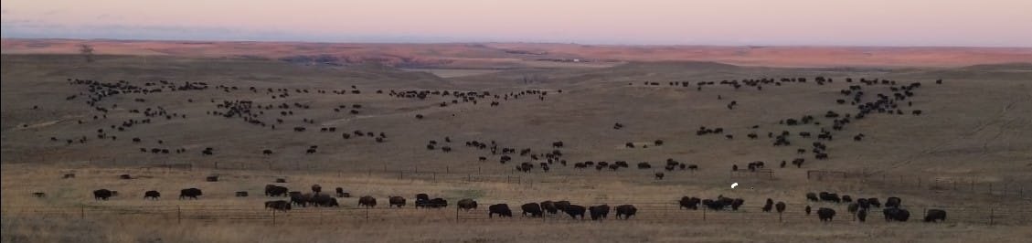
The Johnson buffalo herd grazes a large pasture here. In the distance, at center, is Shadehill Lake and Shadehill Buffalo Jump. Photo courtesy of Donna Keller.
The River Grande waters a good chunk of North and South Dakota—and from time immemorial it has always been the place where Buffalo live, graze and multiply.

The South Grande in spring. Photo courtesy of Francie M Berg.
For those of us who have put down roots here in the Hettinger-Lemmon-Bison-Buffalo area, we can take pride in the fact that this is the ONE PLACE in the world where the entire buffalo story comes together. This is our Legacy!
Here are centuries-old buffalo jumps and traps. Three of the Last Great Traditional Native American Hunts of an Ancient Species, noble and majestic.
But, it seemed, inevitably the buffalo were bound for extinction. William Hornaday wrote his 1887 buffalo report, published as a book in 1889, with that in mind.
And then almost suddenly—came the amazing Rescue of Buffalo calves. Rebirth of healthy herds. And their flourishing again today in tribal herds as well as private and public herds.

Healthy buffalo herds flourish today in tribal lands, in private and public herds. Ft. Peck, Montana, tribal herd. Photo courtesy of FM Berg.
Surely ours is a Legacy of history, culture and adventure. We have stories to learn. Stories to share. We need only discover what happened by the River Grande over the centuries. For that, we need to learn from oral histories of Native Americans.
When we moved here to Hettinger, in 1966 my husband Bert and I—with our two oldest children—would now and then, see people going over recently-plowed fields by Hiddenwood Cliff with metal detectors.
They searched for ancient arrowheads, military buttons and buffalo bones—near Hiddenwood where Native American hunting parties and General Custer had camped and left treasures from long ago.
Migration of the Last Herd
My interest in Buffalo began as a kid when my younger sister Anne and I found a Buffalo skull.
After the snow melted that spring of 1947, it sent rushing waters to flush out dry creek beds. We were riding the higher reaches of our range 10 miles east of Miles City, Montana looking for a lost heifer.
In a glint of bright sunlight we saw something peeking out from under a sagebrush that had been partly torn loose from a sandy bank.
“What’s that?” Anne circled her horse across the gravel creek bed.
“Looks like a bone—a horn.”
Sliding off our horses we scrambled up the bank for a closer look.
Yes! Not just a horn—but a horn solidly attached to the head. As we freed it from the big sagebrush tangle, out came a nearly perfect skull with matching stout curved horns—gleaming white in the sun. We hefted the weight of it—bigger and bulkier than any skull we had ever seen.
A relic of long ago—a buffalo skull! The black horn caps had loosened and washed away in the 70-some years since wild buffalo had roamed these ranges.
We’d seen the famous photos of dead buffalo, slaughtered across this very range by hide hunters, as photographed by L.A. Huffman, who set up his studio in Miles City just in time to record that final kill.
Sitting Bull was there at the end. He and his party of hunters came with their families from their agency west of Mobridge to the western edge of their Great Sioux Reservation and slaughtered the last buffalo grazing there. It was October 1883.

Above and Below: Photographer L.A. Huffman arrived in Miles City Montana in time to film the buffalo slaughter in eastern Montana. Huffman photos from 1880.

Later we learned the Hettinger area on the River Grande was where this last big herd of buffalo came in their final desperate flight from big guns in 1880.
The southern herd was already gone. Slaughtered in the mid-1870s. All buffalo were gone from Kansas to Texas as decimated by white hide hunters.
Buffalo didn’t migrate north in the fall. But by all accounts, these last buffalo did. This last desperate herd of around 100,000 buffalo were not seeking warmer climate that fall, but rather, safety.
Blazing guns right behind, they trekked up from Wyoming and hit the little cow-town of Miles City, which had sprung up to fill needs of the new military Fort Keogh. Built at the mouth of Tongue River in the year following General Custer’s disastrous Battle of the Little Big Horn, it was becoming a thriving cow-town.
When the buffalo hit the Yellowstone River, half the herd plunged in, swam across and travelled north—right into the rifles of hundreds of hide hunters. That half did not survive long. Within months all were dead.
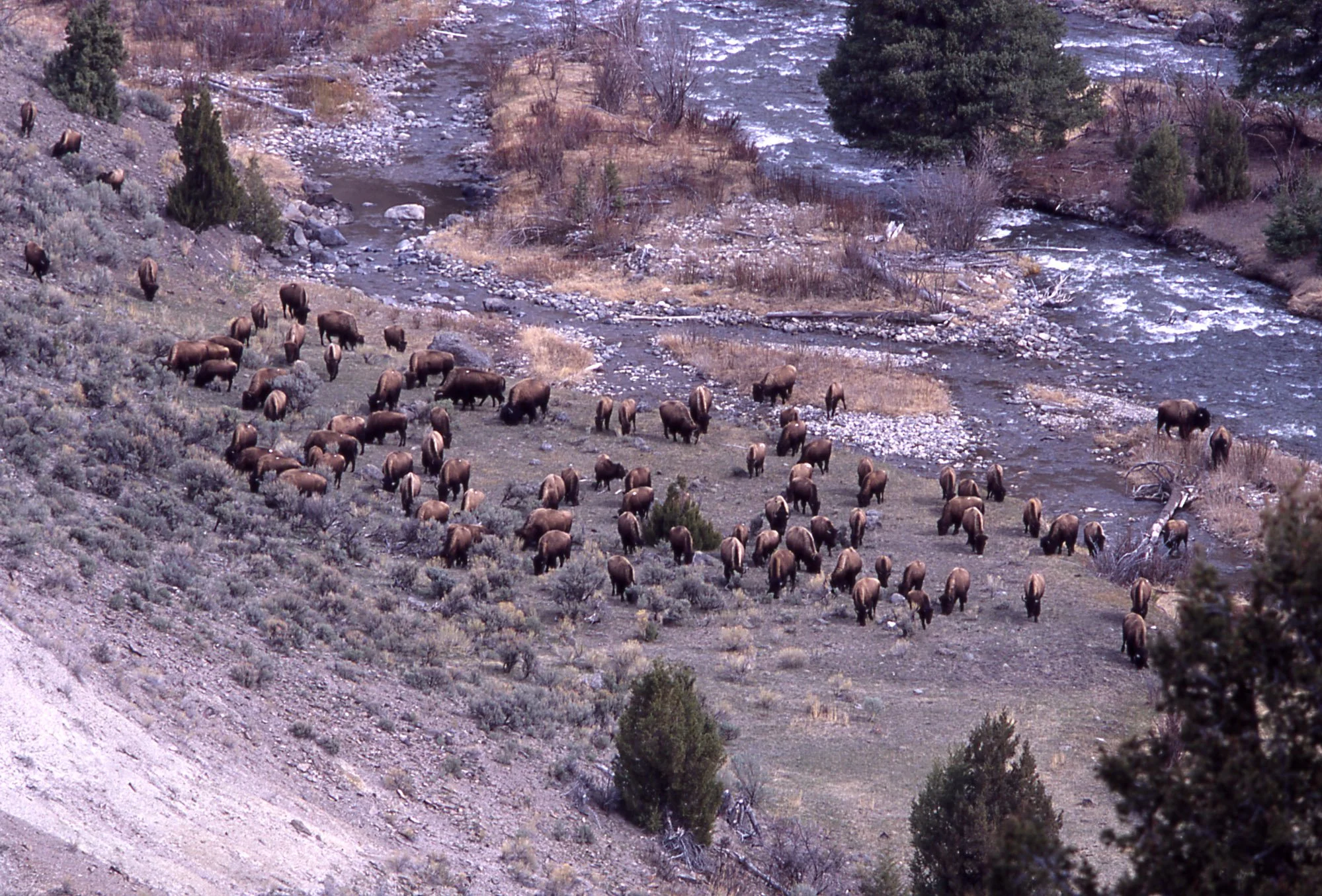
Half the last big herd of about 100,000 buffalo swam the Yellowstone River near Miles City, Montana and travelled north into rifle fire from hundreds of hide hunters. The other 50,000 stayed on the south side and travelled north and then east into Lakota reservation lands in Dakota Territory. Photos courtesy National Park Service.

Some wild instinct led the other half—the last big herd of some 50,000—more directly north and east—on our side of the Yellowstone. They then cut across the corner of Montana.
Apparently, they turned east where the Powder River and O’Fallon Creek flowed into the Yellowstone River, then followed those plateaus and waterways into Dakota Territory.
This was about 150 miles east of Miles City on the border of what became North and South Dakota. It was where these last 50,000 from the great northern herd made their last stand.
There they found safety for a time in the Short Pines of the Slim Buttes. And just beyond that, on the diminished Great Sioux Indian Reservation itself.
Was the bull of our old skull part of that last desperate flight for a place of sanctuary? That last migration in the dead of early winter—December 1880?
Anne and I wrapped the skull in a jacket and tied it behind my saddle.
At home we cleared a place for it in Mom’s flower garden near our front door, next to a yellow rosebush.
Many times our family and visitors speculated over how that bull had lived and died.
Had he grown old and weary, tagging along behind that very last herd and met his fate when attacked by hungry wolves? Alone, he couldn’t have lasted long.

Packs of wolves followed each buffalo herd, attacking those who lagged behind, too old or weak to defend themselves. Lithograph from George Catlin, ‘North American Portfolio.
Years later when my family moved to Hettinger—in July 1966—my husband Bert, as the new veterinarian was eager to help local ranchers care for their cattle, horses, sheep, sheep dogs—and, yes, a few herds of buffalo!
We didn’t know we were coming to the place where those very buffalo from Miles City had made their last stand here on the Grand River—or La Riverre Grande as the early French fur traders called it.
We also didn’t know that my grandparents—the Tom Barretts had staked out their first homestead claim on Lodgepole Creek where it flowed into the South Grand River. They lived in a dugout in the side of a hill. To learn more about the Barretts, click here./p>

At their new homestead on the River Grande my grandparents lived in a dugout in the side of a hill with their 4 young children. This photo could have been one of their neighbors who took the opportunity to set out their finest for a traveling photographer. Photo US Dept of Agriculture.
As newcomers to Hettinger we heard a few rumblings from old-timers. “The last big buffalo hunts were here!”
“What? What do you mean?” we asked. "The last hunts where? In North America? In North Dakota?”
“I don’t know—that’s what they say,” came the inevitable answer.
A few old-timers who lived at Haynes—a little town halfway between Hettinger and Lemmon SD—knew about this Legacy and its stories, in part, although they were not written down.
We discovered that bits and pieces were passed down word-of-mouth from grandparents—who dug outskulls and bones to line their flower beds.

The small town of Haynes today keeps up its park with church bells, but the elevator and school are no longer viable entities—they may serve other purposes. A few old timers at Haynes knew stories of the Hiddenwood Buffalo Hunt and told them to grandchildren. Photo FMBerg.
Local people insisted these were the last hunts. But I wanted to know more. What did that mean? I had to read it in a book and started a search.
Sure enough, several books held promise—claiming special knowledge of the very last hunts. But their ‘last hunts’ always turned out to be big guns, big slaughter, rotting carcasses left across the Plains—in Kansas or somewhere even farther south.
Everyone knew the shameful history it seemed.
Even Canada geese could hardly nest in North Dakota at that time because of overhunting. The new settlers were desperate for meat.
Then one day, browsing our local library, I came across a little-known book of memoirs, My Friend the Indian, by James McLaughlin, Indian Agent at Ft. Yates.
Flipping pages, back to front, I found myself reading an amazing tale in a chapter called simply ‘The Great Buffalo Hunt.’
Suddenly there it was—all laid out, step by step—the Hiddenwood hunt of June 1882 told in complete and fascinating detail by a man who was here and on that hunt.
McLaughlin described the showy march of the Native hunters riding out of Fort Yates—resplendent in their best hunting attire.
Six hundred mounted riders wove in and out among people walking and riding in buckboard wagons. Their prancing horses painted in traditional ways, they struck out for ancient buffalo hunting grounds—to what is now our Hettinger community.
McLaughlin told of the trip in detail. Religious traditions and prayers for success were honored at significant stops along the way.
He and his teenage son hunted here, with 2,000 Native Americans, right outside our living room window, riding up Hiddenwood Creek, which runs through our town. He described it all in his book of memoirs “My Friend the Indian.”

The Scouts—8 young men selected for good moral character, honesty and hunting ability—took an oath, smoked the pipe and rode out ahead of the Ft. Yates hunters to find the herd. On the 4th morning out they flashed a mirror signal from 10 miles off: “Huge herd of buffalo within sight!” Painting by CM Russell 1900, courtesy of Amon Carter Museum.
Later another jewel appeared in a dusty collection. The memoirs of Congregational missionary, Thomas Riggs, stationed at Oahe near Pierre, offered another Buffalo Hunt section.
Again, an amazing story, told by an articulate and sympathetic man who came in December 1880 to the Slim Buttes—with a small band of traditional Lakota hunters on a long, three-month winter hunting adventure.
Both these hunts were traditional, conducted with religious fervor and ancient ceremony. All three, including the buffalo’s last stand—the Sitting Bull hunt in 1883—were on or near the Great Sioux Reservation of North and South Dakota.
Both fit perfectly into William Hornaday’s well-documented history of 1889, The Extermination of the American Bison; With a Sketch of its Discovery and Life History, written as an official report in 1887 and published two years later as a 170-page book.

These 3 books are the source of information for the 3 Last Hunts on the Great Sioux Reservation in ND and SD (1880-1883). They are by James McLaughlin, ‘My Friend the Indian;Indian’ (1910); Thomas Riggs, ‘Sunrise to Sunset’ (as told to his niece Margaret Kellogg Howard in 1927); Wm Hornaday, ‘Extermination of the American Bison’ (published in 1889, as the 1887 report of the Smithsonian National Museum).
After the wild herds were gone the Smithsonian Museum sent Hornaday—their leading taxidermist—out west to report on how the disastrous buffalo slaughter could have possibly happened and to bring back some museum-worthy carcasses, if possible.
In researching his book, Hornaday really thought he was writing about the final hours of what he called “this magnificent animal.”
Determined to get it right, he spared no effort in contacting every possible source of buffalo knowledge, from Army officers at far-flung western forts to fur traders, railroaders, hide hunters and cowboys.
Hornaday learned that the end came right here on the North Grande, near what is now Hettinger, but offered few details.
Except he wrote that Sitting Bull was here at the end and his band killed the last 1,200 buffalo. In fact he recorded the exact dates—October 12 and 13, 1883.
These last buffalo hunt details were virtually unknown in the 1980s, when I read these books. Only a few pioneers and early settlers, who settled here on what had first been designated Indian reservation lands by treaty, knew of the history and they didn’t write it down.
So the best buffalo hunting stories I could find were hid deep in obscure books of memoirs by McLaughlin and Riggs.
Someone needed to put this together on paper.
This is our Legacy, those of us who lived here now and in the past—who’s children were born and educated here. I couldn’t let it disappear again—as it nearly had atone time.
A Historic Site
We also needed a commemorative site—so people would know where that 1882 hunt happened that McLaughlin described—in the wide fertile valley near Haynes, ND—halfway between Hettinger and Lemmon, SD.
With farming, that valley was now filled with rock piles gathered from tepee rings and ceremonials that once marked those famous Native hunting lands.
Our Dakota Buttes Visitors Council (DBVC), of which I’d been a charter member since its beginning, agreed to take this on. One of our first projects was designing and setting up 6 billboards feting the “Last Great Buffalo Hunts.”
My son-in-law Todd Halunen, an architect, sketched us a plan for the Historic Site. The Visitors Council guys, Jim Goplin and his crew, did the cement work. Gladys Wamre donated the land; her son Duane, a surveyor in Dickinson, took care of the legaldetails.

Our historic site on US Highway 12, halfway between Hettinger and Lemmon, highlights the June 1882 great hunt by 2,000 men and women from Ft. Yatesas described by Indian Agent James McLaughlin. In 3 days the 600 mounted riders killed 5,000 buffalo, and together the 2,000 women and men from Ft. Yates worked hard for a week or more to preserve the hides and meat. Photos by FMBerg

We planted trees, watered and hoed weeds through a couple of hot, dry summers with Duane Wamre’s help and water truck.
I designed signs and wrote grants to pay for them. Mark Baker located an authentic Lakota tepee on the reservation, set it up with Native help and maintained it for many years.
David Seifert donated and came down one morning with his neighbor and two large petrified wood rocks from his rocky hilltop farther north, along with the equipment to place them.
It was all worthwhile the day Jeff Rotering brought Haynes people and other visitors to the creek site in a school bus. They got settled, then I walked up out of the creek bed in my buckskinner garb.
I told McLaughlin’s story of that 3-day hunt in which Native women had important tasks—to dry tons of meat and hides from the 5,000 buffalo killed—just as important as the work of the hunters.
Afterwards, Gladys Wamre told me, with hand over her heart, “I’ll NEVER FORGET that moment you walked up out of the creek! My heart just leaped.”
She had deeded the site to us. And we dedicated the site to her.

We arranged several Black Powder Shoots and tours over the years for Buckskinner groups at what we now call ‘The Buffalo’s Last Stand at the Hunt Site of Sitting Bull and his band,.’ (Once known as ‘The Butchering Site.) Photos by Dakota Buttes Visitors Council.

Francie Berg in the doeskin dress made special for her.
Learning Book Publishing
From these three sources came a carefully-researched booklet, in which I brought together for the first time the full story of the last stand of the American buffalo and their final dramatic moments.
By this time I had a publishing business of my own and a part time assistant to help with the brand new computer skills just beginning to amaze us with the printing we could accomplish all on our own. To learn more of Francie’s publishing history, click here.
In the mid-1990s our Dakota Buttes Visitors Council donated copies of my booklets titled (Italic) The Last Great Buffalo Hunts: Traditional Hunts in 1880 to 1883 by Teton Lakota People just off the press, to local schools. We sent copies to the Native American schools in ND and SD—with an offer to send more free of charge.
After all, as I had hoped¸ the book turned out to be filled with stories that the Native kids own grandparents told them. That’s where I found the stories on the Last Great Traditional buffalo Hunts—right here from neighbors, both Native and white and the three books.
Our tourism group started taking people on bus tours of our three Historic Last Great Traditional Native Hunts. Free of course. We were all volunteers.
For the first time local people—and readers throughout the country—learned the full story of the last stand of the American buffalo and these last dramatic moments. It was the majestic Legacy of the River Grande!
Until then, somehow this final triumph of the buffalo saga had fallen through the cracks in our national and state histories. It was a story not generally known by anyone except perhaps some old-timers from Haynes.
Still, it seemed like the end of the story.
But wait! There’s more.
I started collecting Buffalo stories for another book. Marvelous stories. Word of mouth stories. It was like peeling an onion, one more layer beneath another as layers unfolded, one by one.
Our tour groups wanted to know more. So did I!
By this time we were telling the stories in our local schools and also taking high and junior high students out to some of our historic Buffalo Sites on field trips.
One morning we had a busload of 7th graders. We stopped at my favorite spot on top of the ridge at the ‘Last Buffalo Stand—the Sitting Bull Hunt site.’
Teachers handed each student a sack lunch and they disappeared—hiking eagerly in various directions to explore shady draws and rock-strewn hill tops. I wondered if they’d come back.
But they did! All returned within the hour. Eyes shining and bubbling over with stories of their discoveries.
Over the years our four kids and friends spent hours hiking local Forest Service badlands and buttes, enjoying rocks, caves and evidence of trails and homesteads found here and there.
Bert and I purchased pasture land on the North Grande River for summering cattle and horses. We watched the river rise in springtime—often raging through what neighbors called our “Oxbow” turn in the river, sweeping away our fences.
Our kids fished in the North Grande, paddled small boats and inner tubes and camped on the muddy shores.
One day I said to my husband, “Why don’t we raise some buffalo?”
Made sense to me. We lived at the edge of town, where people could easily drive by—or park to watch buffalo mothers nuzzling their red-gold calves.
But by then Bert was having none of it. Count him as an experienced learner at rounding up and working with buffalo.
He’d already discovered that a buffalo bull—if he chooses—can break through most any fence he encounters.
“I don’t think so,” he intoned in his new-found wisdom.
“Why not?”
“Too dangerous!”
End of that idea. I was overruled!
In Government Pastures
But I was intrigued. As our kids grew older and more adventurous, they loved exploring and camping in the hills of our lands on the Grande and what everyone called Government Pastures.
There are a number of these federally-owned pastures along the South Dakota state line, close to where we live, separated here and there by private land and ranches.
Land on which the new owners could not pay their taxes during the drought years of the depression—which was through most of the 1920s and 1930s. Hard times for settlers from farther east—who might not have expected this!

Our kids and friends enjoyed hiking and exploring the rocky buttes—which look today much as they have for thousands of years. Photo by FMBerg.
Our family learned these Government pastures were Multi-Purpose—for public recreation as well as cattle grazing.
United States Forest Rangers had rules—but also amazing flexibility. With a car or pickup you are required to stay on the designated road and of course shut any gate you opened.
But we could hike, bike (non-motorized), ride horseback anywhere in the pastures, even camp where ever we liked for free, exploring the rugged badlands and scenic draws. These ancient buttes look much as they have for thousands of years.
Amazingly, I discovered we had a real buffalo Jump at Shadehill. We didn’t call it that, because I wasn’t sure. People said it was a ‘mass of bones’ on the open side of a steep cliff.
“Maybe it was lightening that chased buffalo over that cliff,” they said.
Dakota people don’t boast or brag much. So they—and we—dared not claim it for a buffalo Jump. Our family came too late to see the bones but I learned what happened to them when interviewing an old-time rancher in the neighborhood.
The rancher, Don Merriman told me it happened during wartime—World War II, in the 1940s.
His neighbor, the land owner, bulldozed all the bones out and shipped them by train to west coast munition factories. The phosphorus in bones were used to manufacture bombs and other explosives.
People on the home front did all they could to help win that war! We girls had hoed sugar beets, and his neighbor sacrificed the best part of his buffalo Jump.
Before that happened, those rust-colored buffalo bones showed up in two wide bands—totaling 16 ft deep and 100 feet long across the face of Shadehill Cliff. My Aunt Margaret Durick Barrett and her sister Dorothy Kroft saw them during a White Butte school field trip when they were in elementary school.
Then all-of-a-sudden one day I noticed the South Dakota Game and Fish Recreation that manages Shadehill Park and Lake had planted a new sign at the edge of the lake—with a picture of buffalo jumping off that very cliff and a message that this was indeed a Buffalo Jump.
Three archaeology teams had reported their findings—one each from the University of North Dakota, SD Game, Fish and Parks and the US Dept of Interior Bureau of Reclamation.
UND even published a book of their findings. And local Perkins County Agent Vince Gunn—who lived most of his life across the lake from the jump—lent me his copy.

Without horses, ancient hunters for 7,000 years risked their lives during buffalo drives to prevent them from turning back at the cliff’s edge. Painting from Jack Brink’s book “Imagining Head-Smashed in,” with permission from the author.
Although the bones were gone. our jump was real. The official sign verified it!
And buffalo were still alive here by the River Grande in several private herds!
The experts’ dig at our buffalo jump at Shadehill Lake revealed that primitive hunters used it likely 7,000 years ago. Wow!
Along with ancient buffalo bones my grandparents’ homestead was buried there under the lake by dammed-up waters.

The Shadehill buffalo jump is across on the south side, as depicted in the second sign from the left. The older stone monument at the far left honors Hugh Glass—who was attacked in those same trees by the jump in 1823 by a grizzly bear and left for dead by Major Henry’s fur-trading party. Photo FMBerg.
Over the years I had located 8 historic buffalo sites in our area (plus 2 not far off, but in ND). Our Dakota Buttes Visitors Council agreed to order and place a durable metal sign at each. Of course, our crew had to jump through a few hoops to officially establish them.
Most were on US Forest Service lands. And they had rules. On their end, decisions had to be cleared all the way through Washington, DC.
But the local Forest Rangers in the Lemmon office sent in the paperwork for us.

The Slim Buttes with a view of its huge outcroppings called ‘Castles and Steamships! We labelled the south highway with a Number 4 Site to place our DBVC yellow Historic sign and the closer highway 4b. Below is the Dakota Buttes Visitors Council sign depicting the area. Photos FMB.

I met with Forest Rangers in their Lemmon headquarters several times through the years working all this out. And a couple of times drove with those same Rangers to potential spots where we pondered the pros and cons of what might have happened there.
At times, we also relied on the Forest Service ranchers’ group—the Grand River Grazing Association—for help. They upgraded some of the ‘Designated Roads,,’ smoothed muddy rutted roads, dealt with cattle guards and helped us decide where to place our DBVC yellow Historic Site signs for tourists.
One marvelous day our family friend Otto Schwarz, who worked for the Ranchers Grazing Assoc. left his fence-fixing project to speed up and down over the hills in his pickup with his wife Connie and I on a hair-raising ride—over what have to be some of the roughest hills and valleys around! Mostly in Pasture 9.
We were looking for a likely spot where the Duprees might have come over the ridge from their home at the fur-trading post on the Cheyenne River, at the mouth of Cherry Creek, in a buckboard wagon to save new-born buffalo calves in the spring of 1881 or 1882.
We found it! A perfect place on the South Grande where they ‘might have come—or within a few miles of this place.’
Likely they came that next spring in 1881 after their long, cold, 3-month buffalo winter hunt in the pine -covered Slim Buttes.
Of course, there are no buffalo in the Government Pastures now. Grazing only for cattle. It’s a Forest Service rule that was worked out with certain cattle ranchers many years ago.
But 5 or 6 families do own buffalo in our area and run them on private land.
There have always been buffalo on the River Grande. As we note: the Grande River valley is no doubt the only place in the world that has always raised buffalo and probably always will!

Always it seems there have been buffalo grazing and multiplying on La River Grande. Our visitors always love best a tour that includes a herd of live buffalo. They stay on the bus, which stops while the feed wagon circles the herd and Buffalo come on the run. Photo by Ronda Fink.
Now some of the herds belong to white ranchers and some Native, since the original Great Sioux Reservation is close by. Several herds are nearby in state and national parks in North and South Dakota.
I picked up a few buffalo stories from these ranchers. They are brave people, the heroic people who raise buffalo. The animals they work with are huge—and they don’t suffer fools.
I noticed these buffalo ranchers are patient, as well as courageous and calm. They don’t yell at their livestock— like cowboys do. (Oh yes, cowboys yell!)
But buffalo owners don’t shout, push or hurry their livestock. Why is that? Hmmm.
It’s their stories that stir the soul. The mystique of the buffalo. Especially when those stories are told by Native people.
For them buffalo are a long-standing Legacy with great significance and deep cultural and religious meaning.
Buffalo are Alive here on the River Grande! Always have been. Likely always will be!

Buffalo hang out near the pines on private land. Photo courtesy of NPS.
Fortunately, William Hornaday had it wrong. He did not write the last chapter on dying buffalo in 1887, as he’d expected!
Most marvelous—was the miracle of how buffalo evaded extinction and the people who saved them. Surprisingly, our depressing buffalo story ended well after all!
Yes!!
Buffalo Calf Rescue
Before the buffalo were all gone, five families rescued buffalo calves and nourished them into viable herds that were healthy and multiplied.
I was delighted to discover that one was a Native Lakota family from this area—the Duprees. Just before the end, they rescued 5 calves on the South Grande Riverre. (As verified in the North Dakota Schools curriculum.)
The Dupree’s long cold winter hunt in the Slim Buttes lasted from December through February in 1880 and 1881.
Then either the next spring or the following one, the Dupree men and probably their sisters too—theirs was a large family—had traveled some 50 or 60 miles in a buckboard wagon from their fur-trading homes at the mouth of Cherry Creek on the Cheyenne River.
A two-day trip with team and wagon.
Back home they found range cows to mother up the young calves they captured.
Pete Dupree must have done things right to avoid the typically high death loss of orphan buffalo calves.
Because his herd kept growing. By the time Pete died in 1898 his buffalo herd had increased to 83.
For many other would-be rescuers, small calves died of starvation before they received the nourishment needed.
And most horrifying: Cows and older calves that were roped simply stiffened out and died of a heart attack instead of giving in to ‘being saved.’

Young calves need colostrum—a mother’s first milk—to survive. The Duprees mothered them up successfully with range cows. Photos courtesy SD Game, Fish and Parks and NPS.

Five North American groups and families are honored as pivotal in saving the buffalo from extinction. They are:
1. The Pete Dupree and Scotty Philip families in South Dakota
2. Samuel Walking Coyote or his son-in-law and herd purchasers Charles Allard and Michel Pablo in western Montana
3. James McKay, a Metis, and neighbors of Manitoba, Canada
4. The Charles Goodnights of Texas, and
5. CJ “Buffalo” Jones of Kansas
Three had Native American roots—the Duprees and Scotty Philip (married to a Sioux woman) , as well as Samuel Walking Coyote and James McKay.
All were western ranchers as well as buffalo hunters.
Apparently the Duprees were the only rescuers who kept their buffalo herd in their home area—on the Great Sioux Reservation where they had free grazing. Theirs is a heroic story we can all be proud of!
Without these 5 family groups we’d have no live buffalo to enjoy visiting and telling stories about today.
Conservationists including easterners William Hornaday, President Theodore Roosevelt and George Bird Grinnell played a part too, by making sure buffalo herds live safely in refuges and wildlife parks.
But without the rescue and nourishing of newborn calves by ordinary people in the west—without boots and moccasins on the ground—those efforts would have failed!
Saving the History
My next book was intended to celebrate the buffalo—as well as Native people of the Plains who for thousands of years hunted buffalo on foot and carried their possessions with them in dog travois.
My former editor and co-worker Kendra Rosencrans, glanced at the contents and told me bluntly. “People don’t read books anymore!”
Ouch!
But I took her advice and finished the Self-Guided Tour book first—in 2017. ‘Buffalo Trails in the Dakota Buttes’ is an action book to take along while visiting the 8 historic stops in our area and 2 nearby sites.
Sites 9 visits two Lakota Standing Rock tribal herds fairly close to the highway near Fort Yates. Then many travel on to Site 10—the National Buffalo Museum in Jamestown—both in North Dakota.
As it turned out I wrote three buffalo books.
1. In the 1990s, a 46-page booklet on ‘The Last Great Buffalo Hunts: Traditional Hunts in 1880 to 1883 by Teton Lakota People.’
2. A Tour Guide of 10 Historic sites ‘Buffalo Trails in the Dakota Buttes: Self-Guided Tour,’ 2017.
3. And the rest of the story: ‘Buffalo Heartbeats Across the Plains: The Last Great Hunts and Saving the Buffalo,’ 2018

Our three books that focus on early Buffalo history. The ancient stories are told from oral history by Native Americans.
Seems like our Native American friends can name every butte between here and Bismarck!
And on the BSC buses from Bismarck in June, 2022 they told stories about what happened on these buttes—including strange legends of mysterious ‘little people” inhabiting some of the buttes.
We need to hear those stories too—in their own voices. Yes!
The cultural stories are still here, safe with Native Americans. So let’s listen!
There are plenty of stories of our own buffalo experiences for the rest of us to delve iinto.
Truly, the almost-tragic Buffalo story of saving the buffalo, as we know it is one of the greatest conservation stories of all time.

Now Buffalo are coming home to Tribal Reservations, Wildlife Preserves, National Parks and private ranching. Photo by Chris Hull with SDGFP.
And now Buffalo are coming home in great numbers to Indian Reservations, to Wildlife Preserves, National Parks and private ranching.
This is our Legacy! All of us who live here and put our roots down here—whether it’s been 7,000 years or only a few!
Sharing the Story
When Bismarck State College decided in early 2020 to put on a Bison Symposium led by their retiring director Dr. Larry Skogen, we got involved. In fact, we may have helped inspire the whole thing.
After all, Larry grew up in Hettinger, where his parents ran a hardware store. He knew something of our buffalo heritage. This is his Legacy too!

Our Bismarck State College tour bus visiting the Blair Johnson herd near Hettinger. Herd Manager Jim Strand circled the herd with his feed wagon and the buffalo came running. Here, Jim steps on the bus and explains how he handles buffalo. Since they can be dangerous if stressed, our guests stay on bus and take close-up photos and videos to their heart’s content through the large windows. Photo by Kathy Berg Walsh.
What other university institution has dared to put on a three-day event that includes all we poured into this one?
Academic speeches. Native Americans telling how their culture is still intimately bound up with the buffalo. History tours of where it all happened.
A bit of hiking for those who are able. A tour through a live buffalo herd. And a lot of great bison meals including a final Bison Stroganoff dinner!

Travelers on the June 22-25, 2022, Bismarck State College Bison Symposium enjoy their sack lunches in the shady park at the Shadehill Recreation site across the lake from the Buffalo Jump. At table in foreground are Lakota storytellers Dakota Goodhouse (at far left) and Kevin Locke (center). They rode the two buses, told stories and history and identified ancient landmarks on the drive from Bismarck. Photo FMB.

Hoop dancer Kevin Locke demonstrated his hoop dancing skills one evening. Photo FMB.

Most visitors enjoyed a bit of hiking along the draws and rocky hilltops at the Buffalo Last Stand and Sitting Bull Hunt Site. Photo by James Kambeitz, with permission.
The second day of the BSC Symposium was spent on a bus tour in the Hettinger-Lemmon area.
About 80 people rode the two big travel buses that day to our designated historic sites.
The visitors said they loved the tour, the Native storytellers and driving among 400 live buffalo while the herd manager, Jim Strand circled the herd with the feed wagon.
“When will you do this again?” they asked.
Whew! We were exhausted. But it gave us an idea.
Polishing our Legacy
These questions led to a series of sessions around my kitchen table. A few local people concerned about the loss of our buffalo history.
A working group that gathered and talked about what we could do. We all wanted to know—what makes sense—and where to take our stories—where to start?
There are more stories in these buttes and grasslands. Of course there are. We haven’t heard them all yet.
We haven’t even told all the stories we know. Maybe there is something we can do about our Legacy before it all disappears in smoke, as it once almost did. To learn more about Buffalo Grande’s team, click here.
We have a Legacy, sure enough, and exciting Buffalo stories worth telling. But frankly, we are already stretched too thin.
What we need is tourists coming from afar—appreciating our long buffalo history and modern day buffalo ranchers. We have confidence visitors from around the world will love this. But how do we make it happen?
Our mayor Jim Lindquist—a very perceptive young man—said, “Wait! We need to build a good Website. That’s how people get their information today!
“But it has to be good!” he insisted.
Those of us a generation or two older did not see it at first.
However, Val Braun and I sat down together for an afternoon, again at my kitchen table. Like me, she’s a former County Extension Agent and Consumer Science teacher— meaning we have learned to work with a wide variety of community people.
We listed all the things we’d want to have on a website. And surprisingly, we discovered ALL of them could first be revealed on a well-designed professional website.
Could they be later backed up with more of the real thing? Of course!
But Jim was right. First things first.
Epilogue: Trails Impact our Legacy
Oh Yes! There’s at least one more Historic place I’ve wanted to visit.
And now I have been there. Honest to goodness Buffalo Trails trod centuries ago and Buffalo Wallows, likely used by large migrating Buffalo herds.
Only a few miles north of Hettinger, near the Cedar Creek.
My family has been friends with these ranching families to the north, along the Cedar, for at least 40 years—or more!
We’ve been invited to take this trip for at least forty years—to see their buffalo trails and buffalo wallows. Was I always too busy to go? I don’t think so—but somehow it just didn’t happen.
As their veterinarian, my husband Bert may have seen those historic trails and buffalo wallows, but never described them to me! Now he’s gone.
But—now I have been there! And they are impressive! Honest to goodness Buffalo Trails trod centuries ago, by generations of migrating Buffalo herds. To learn a little more about how buffalo trails are made, click here.
They are only a few miles north of Hettinger, in the general area where Cedar Creek crosses under Highway 22 on its way east to the Missouri River. And there are lots of them.
Allan and Virginia Earsley, ranchers in the Cedar Creek area, offered a motorized side-by-side ride for Dr. John Joyce and me to that special hill and ravines in their pasture where original buffalo trails show up best in spring.
Or maybe in the fall. We plan to shoot some fall photos, too. And maybe I’ll take some more in early spring, when the grasses are just peeking through.
It does make an impact to actually see these trails and re-live what was going on in those days.
Older neighbors and Allan’s grandparents identified the Buffalo Trails before cattle began making their own trails. Early settlers told their families these were NOT cattle trails.
They told stories of trails made by big herds—had to be wild buffalo! Maybe in the thousands!

When it’s time to go somewhere special a matriarchal grandmother takes the lead. Like heading down to Cedar Creek to drink; she takes off and the herd follows single file. Photo courtesy of SD Tourism.
Trekking down to water in the Cedar Creek day after day. Cutting deep narrow grooves in the hills as they apparently went single file—with a matriarch cow leading, just as buffalo tend to do today when the herd is headed somewhere—such as to water.
Down the hill they went—single file--then back up onto the grassy plateau where the herd spread out to graze again.
In another season and yet another, they returned to follow the same trails—ancient trails that seemed to cut across fences the newcomers built.
I wanted to take that ride to see the trails. Could hardly wait till spring when grass began to green up and reveal these mysterious trails. Known first to original settlers who refused to plow them up—and passed their stories on to grandkids—although unfortunately they didn’t write them down.
These majestic trails are another part of our Buffalo Legacy. Yours and mine!

Apparently these were buffalo trails where buffalo went down single file to the Cedar Creek to drink and then turned around and walked back up onto grassy plateaus to the south to graze.Across the creek to the north, other trails came down to the Cedar—and returned after watering. Photos by FMB.


Young bulls follow the leader across a pasture near the Slim Buttes in single file. Some of the old single-file trails are still here, having cut deep grooves into the landscape. Photo FMB.
Buffalo Wallows
Back up on the plateau where the grazing is good the herd would have scattered to fill their bellies.
One hundred and 50 years ago after a quenching drink it may be that many individuals sought a nice comfortable wallow.
The wallowing evidence is here as well. There’s a School Section—which has never been plowed and is now divided into 4 pastures for rotational grazing of cattle—that holds many old buffalo wallows.
Tom Schoeder took Connie Messner and me on another “side by side” to see the wallows in that school section.
They tend to be almost round—perhaps 9 to 10 feet in diameter and 2 ft in depth. And there are lots of them, nearly all filled now with green grass. Perhaps made by thousands of buffalo over their many migrations.

Tom Schoeder told Connie Messner and me that his family called the depressions “knolls,” perhaps because they tend to be found on the higher ground. There were many, perhaps 50 or more. Wonder how many buffalo that represents? Photos by FMB.

Connie Messner and Tom Schoeder stand along the side of a faintly visible wallow. Photo by FM Berg.

Connie Messner, Buffalo Grande Foundation member, walks across the prairie in front a very visible wallow. Photo by FM Berg.

Buffalo Grande Foundation member, Connie Messner stands on the prairie next to an overgrown wallow with a less visible one in the foreground. Photo by FM Berg.

Landowner Tom Schoeder stands on a knot in the midst of numerous buffalo wallows. Photo by FM Berg.

Connie Messner stands to the left of a large wallow while Tom Schoeder stands to the right. Photo by FM Berg.
We estimated perhaps 50 or 60 wallows in a single pasture (90 acres). They seem to be clustered more heavily together along somewhat higher land than down on the Cedar Creek itself.
Tom said his family called the wallows “knolls,” evidently to recognize their placement on higher ground.
Jim Strand, Buffalo Herdsman, tells us that when flies are bad, or it’s hot, his buffalo will seek higher ground where they can catch a breeze.
For a wallow they like sandy soil and will throw dirt and dust up over their backs. If a wallow happens to contain rainwater, well, splashing mud around and onto their own hides makes it even better!
In her report of the Buffalo Wallows Conni Messner wrote, “Driving west on Hwy 12 and north on Hwy 22, we met Tom not far from the turn on 18th Ave. He led us to a section of land that is being used for grazing but since it is School Land it has not been used for agriculture.
“We jumped onto his 4 by 4 and drove to many sites that Tom remembered his grandfather telling were made by buffalo rutting in the dirt.
“We must have seen approximately 50 depressions. Some of these wallows were on flat land and some were up on what he called the knolls—or ridge line. Tom said the Wallows were more visible when he was a child.
“Cedar Creek was flowing and he related that the buffalo would drink here before heading south to their grazing area.
“Tom was very clear in the fact that he was not an expert on this history and this information he was sharing with us was from his childhood memories.
“He also stressed that this land is Our Land owned by the State of North Dakota and can be visited without permission.”
And we recorded what we could of the remembered words from our hardy pioneers who saw them first—and recognized the trails and wallows as ancient evidence of our legacy—where thousands of buffalo once tramped the ground and thrived.
Now our Buffalo Grande group has done it. We took photos of the buffalo trails and the wallows.
These majestic trails and wallows are just another part of our Buffalo Legacy. Yours and mine!
They fit in perfectly with the Historic Buffalo sites we celebrate in our Hettinger/Lemmon/Bison/Buffalo area.
So whether your family has been here 7,000 years or just a few—if you’ve put down roots in this community, this is your Legacy—yours and mine! It’s a Buffalo legacy of which we can all be proud.
Let’s keep their stories coming! Surely, there are more!